Louisiade-Archipel
| Louisiade-Archipel | ||
|---|---|---|
 | ||
| Gewässer | Pazifischer Ozean | |
| Geographische Lage | 11° 0′ S, 153° 0′ O | |
| Anzahl der Inseln | 90 | |
| Hauptinsel | Misima | |
| Gesamte Landfläche | 1600 km² | |
| Einwohner | 17.000 | |
 | ||
Der Louisiade-Archipel ist eine Inselgruppe im äußersten Südosten Papua-Neuguineas. Der Archipel umfasst ca. 90 Inseln und hat eine Gesamtfläche von 1600 km².
Die Inselgruppe gehört zur Provinz Milne Bay des Staates Papua-Neu-Guinea.
Geographie
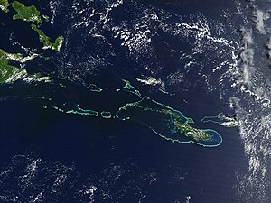
Der Archipel liegt an der Grenze zwischen Korallenmeer und Salomonensee. Die größten Inseln sind Vanatinai (auch Tagula oder Sudest) mit einer Fläche von 867 km², Rossel (auch Yela) mit einer Fläche von 260 km², Misima mit einer Fläche von 200 km², Sideia mit 107 km², Basilaki mit 100 km², Pana Tinani mit 78 km² und Panaete (auch Deboyne) mit 30 km².
Sideia-, Basilaki Island und die Dumoulin-Inseln liegen nahe der Küste Neuguineas. Misima, Vanatinai, Rossel und die Duchateau-Inseln liegen weiter südöstlich.
- Inselgruppen
Im Archipel liegen u. a. die folgenden Inselgruppen bzw. Atolle:
- Bonvouloir-Inseln mit der Untergruppe der Strathord-Inseln
- Bramble-Haven-Atoll mit der Untergruppe der Duperré-Inseln
- Brumer-Inseln
- Calvados-Inseln mit der Untergruppe der Sloss-Inseln
- Conflict-Atoll
- Deboyne-Inseln
- Duchateau-Inseln
- Dumoulin-Inseln
- Engineer-Inseln
- Jomard-Inseln
- Lebrun-Inseln
- Obstruction-Inseln
- Renard-Inseln
- Stuers-Inseln
- Torlesse-Atoll
Geologie
Die Inseln sind zum Teil korallinen, zum Teil vulkanischen Ursprungs.
Bevölkerung
Die Inselgruppe beherbergt etwa 17.000 Einwohner.
Hauptort ist Bwagaoia auf der Insel Misima.
Bodenschätze
Auf der Insel Misima gibt es Goldvorkommen.
Weblinks
Auf dieser Seite verwendete Medien
Transparent red circle
nautical chart of Louisiade Archipelago, Papua New Guinea, Solomon Sea, Western Pacific Ocean
Off the southeast tip of Papua New Guinea lies a string of small volcanic islands and coral reefs collectively called the Louisiade Archipelago. This true-color MODIS image from September 11, 2002, is centered on the island chain, with Papua New Guinea at the left edge. Moving westward from eastern end of the chain are the islands of Rossel and Tagula. (Misima Island, which harbors the largest village in the region, is obscured by a patch of clouds northeast of image center.) To the north of the chain lies the Solomon Sea, and to the south is the Coral Sea. Most of the undisturbed land is covered by tropical rainforest, and despite their small size, the islands harbor a number of plant and animal species found nowhere else.
Autor/Urheber: Carport, Lizenz: CC BY-SA 3.0
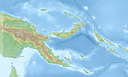
Physische Positionskarte von Papua-Neuguinea


