Liste der Einträge im National Register of Historic Places in Medford (Massachusetts)
Die Liste der Einträge im National Register of Historic Places in Medford in Massachusetts führt alle Bauwerke, National Historic Landmarks und Historic Districts in Medford auf, die in das National Register of Historic Places aufgenommen wurden.
Die vorliegende Liste wurde aufgrund der Vielzahl an Einträgen in Medford ausgelagert und ist integraler Bestandteil der Liste der Einträge im National Register of Historic Places im Middlesex County.[1]
Legende
| NRHP | Historic Place |
|---|---|
| HD | Historic District |
| NHL | Historic Landmark |
Aktuelle Einträge
| [2] | Name[3] | Bild | Eintragsdatum | Lage | Ort | Beschreibung |
|---|---|---|---|---|---|---|
| 1 | Albree-Hall-Lawrence House | 30. Apr. 1976 ID-Nr. 76000256 | 353 Lawrence Rd. 42° 25′ 29″ N, 71° 7′ 12″ W | Medford | ||
| 2 | John B. Angier House | 23. Apr. 1975 ID-Nr. 75000267 | 129 High St. 42° 25′ 12″ N, 71° 6′ 54″ W | Medford | ||
| 3 | Bigelow Block | 24. Feb. 1975 ID-Nr. 75000268 | 42° 25′ 6″ N, 71° 6′ 36″ W | Medford | ||
| 4 | Charles Brooks House | 18. Juni 1975 ID-Nr. 75000269 | 309 High St. 42° 25′ 18″ N, 71° 7′ 28″ W | Medford | ||
| 5 | Jonathan Brooks House | 26. Juni 1975 ID-Nr. 75000270 | 2 Woburn St. 42° 25′ 18″ N, 71° 7′ 26″ W | Medford | ||
| 6 | Shepherd Brooks Estate | 21. Apr. 1975 ID-Nr. 75000271 | 275 Grove St. 42° 26′ 0″ N, 71° 8′ 22″ W | Medford | ||
| 7 | Paul Curtis House | 6. Mai 1975 ID-Nr. 75000272 | 114 South St. 42° 25′ 2″ N, 71° 7′ 1″ W | Medford | ||
| 8 | Fells Connector Parkways | 9. Mai 2003 ID-Nr. 03000379 | 42° 26′ 40″ N, 71° 4′ 45″ W | Medford | ||
| 9 | George P. Fernald House | 30. Apr. 1976 ID-Nr. 76000258 | 12 Rock Hill St. 42° 25′ 14″ N, 71° 7′ 23″ W | Medford | ||
| 10 | Jonathan Fletcher House | 23. Juni 1975 ID-Nr. 75000274 | 283 High St. 42° 25′ 18″ N, 71° 7′ 23″ W | Medford | ||
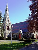
| 11 | Grace Episcopal Church | 3. Nov. 1972 ID-Nr. 72000139 | 160 High St. 42° 25′ 12″ N, 71° 7′ 0″ W | Medford | ||
| 12 | Isaac Hall House | 16. Apr. 1975 ID-Nr. 75000275 | 43 High St. 42° 25′ 7″ N, 71° 6′ 41″ W | Medford | ||
| 13 | Hillside Avenue Historic District | 21. Apr. 1975 ID-Nr. 75000276 | 42° 25′ 13″ N, 71° 6′ 46″ W | Medford | ||
| 14 | Lawrence Light Guard Armory | 10. März 1975 ID-Nr. 75000277 | 90 High St. 42° 25′ 7″ N, 71° 6′ 47″ W | Medford | ||
| 15 | Joseph K. Manning House | 7. Apr. 1989 ID-Nr. 88000712 | 35–37 Forest St. 42° 25′ 11″ N, 71° 6′ 37″ W | Medford | ||
| 16 | John H. McGill House | 9. Apr. 1980 ID-Nr. 80000640 | 56 Vernon St. 42° 25′ 28″ N, 71° 7′ 41″ W | Medford | ||
| 17 | Medford Pipe Bridge | 18. Jan. 1990 ID-Nr. 89002253 | Führt über den Mystic River. 42° 25′ 6″ N, 71° 6′ 44″ W | Medford | ||
| 18 | Middlesex Canal Historic and Archeological District | 19. Nov. 2009 ID-Nr. 09000936 | Entlang des historischen Verlaufs des Middlesex Canal. 42° 25′ 3″ N, 71° 7′ 50,2″ W | Medford | ||
| 19 | Middlesex Fells Reservation Parkways | 4. Feb. 2003 ID-Nr. 02001749 | 42° 26′ 43″ N, 71° 6′ 10″ W | Medford | ||
| 20 | Middlesex Fells Reservoirs Historic District | 18. Jan. 1990 ID-Nr. 89002249 | 42° 27′ 18″ N, 71° 5′ 43″ W | Medford | ||
| 21 | Mystic Dam | 18. Jan. 1990 ID-Nr. 89002282 | Trennt den Lower und Upper Mystic Lake voneinander 42° 25′ 50″ N, 71° 8′ 56″ W | Medford | Erstreckt sich zwischen Medford und Arlington; im Register unzutreffend als in Winchester liegend eingetragen. | |
| 22 | Mystic Gatehouse | 18. Jan. 1990 ID-Nr. 89002284 | 42° 25′ 52″ N, 71° 8′ 52″ W | Medford | Im Register unzutreffend als in Winchester liegend eingetragen. | |
| 23 | Mystic Valley Parkway | 18. Jan. 2006 ID-Nr. 05001529 | Mystic Valley Parkway 42° 25′ 47″ N, 71° 7′ 49″ W | Medford | ||
| 24 | Edward Oakes House | 9. Apr. 1980 ID-Nr. 80000639 | 5 Sylvia Rd. 42° 24′ 43″ N, 71° 6′ 39″ W | Medford | ||
| 25 | Old Medford High School | 6. Okt. 1983 ID-Nr. 83004068 | 22-24 Forest St. 42° 25′ 15″ N, 71° 6′ 32″ W | Medford | ||
| 26 | Old Ship Street Historic District | 14. Apr. 1975 ID-Nr. 75000279 | 42° 24′ 59″ N, 71° 6′ 6″ W | Medford | ||
| 27 | Park Street Railroad Station | weitere Bilder | 21. Apr. 1975 ID-Nr. 75000280 | 20 Magoun Ave. 42° 24′ 59″ N, 71° 5′ 55″ W | Medford | |
| 28 | Richard Pinkham House | 16. Jan. 2008 ID-Nr. 07001399 | 24 Brooks Park 42° 24′ 43″ N, 71° 6′ 35″ W | Medford | ||
| 29 | Revere Beach Parkway | 6. Dez. 2007 ID-Nr. 07001241 | 42° 24′ 15,8″ N, 71° 1′ 49,3″ W | Medford | Erstreckt sich bis nach Everett und Chelsea. | |
| 30 | Isaac Royall House | weitere Bilder | 15. Okt. 1966 ID-Nr. 66000786 | 15 George St. 42° 24′ 43″ N, 71° 6′ 44″ W | Medford | |
| 31 | Salem Street Burying Ground | 27. Aug. 1981 ID-Nr. 81000115 | Medford Sq. 42° 25′ 5,4″ N, 71° 6′ 27,4″ W | Medford | ||
| 32 | Peter Tufts House | 24. Nov. 1968 ID-Nr. 68000044 | 350 Riverside Ave. 42° 24′ 40″ N, 71° 5′ 39″ W | Medford | ||
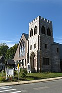
| 33 | Unitarian Universalist Church and Parsonage | 21. Apr. 1975 ID-Nr. 75000281 | 141 und 147 High St. 42° 25′ 13″ N, 71° 6′ 55″ W | Medford | ||
| 34 | US Post Office-Medford Main | weitere Bilder | 18. Juni 1986 ID-Nr. 86001346 | 20 Forest St. 42° 25′ 8″ N, 71° 6′ 36″ W | Medford | |
| 35 | John Wade House | 18. Juni 1975 ID-Nr. 75000282 | 253 High St. 42° 25′ 15″ N, 71° 7′ 18″ W | Medford | ||
| 36 | Jonathan Wade House | 21. Apr. 1975 ID-Nr. 75000283 | 13 Bradlee Rd. 42° 25′ 8″ N, 71° 6′ 39″ W | Medford |
Siehe auch
- Liste der National Historic Landmarks in Massachusetts
- National Register of Historic Places in Massachusetts
Weblinks
Einzelnachweise
- ↑ Auszug aus dem National Register of Historic Places - Middlesex County Abgerufen am 4. August 2016.
- ↑ Die Nummerierung in dieser Listenspalte ist an der vom National Park Service vorgelegten Reihenfolge der Einträge orientiert; die Farben unterscheiden verschiedene Schutzgebietstypen des National Park Systems mit landesweiter Bedeutung (z. B. National Historic Landmarks) von den sonstigen Einträgen im National Register of Historic Places.
- ↑ National Register Information System. In: National Register of Historic Places. National Park Service. Abgerufen am 2. November 2013.
Auf dieser Seite verwendete Medien
Autor/Urheber: John Phelan, Lizenz: CC BY 3.0
Revere Beach Parkway eastbound at Everett Ave, Everett Massachusetts
Autor/Urheber: User:Magicpiano, Lizenz: CC BY-SA 4.0
South Border Road in Medford, Massachusetts, part of the Middlesex Fells Reservation Parkways.
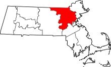
This is a locator map showing Middlesex County in Massachusetts. For more information, see Commons:United States county locator maps.
Autor/Urheber: User:Magicpiano, Lizenz: CC BY-SA 4.0
A photograph of the historic w:Mystic Gatehouse, which controlled the historic Mystic Dam in Winchester, Massachusetts.
Autor/Urheber: User:Magicpiano, Lizenz: CC BY-SA 4.0
A photograph of the historic Paul Curtis House in Medford, Massachusetts.
Autor/Urheber: User:Magicpiano, Lizenz: CC BY-SA 4.0
A photograph of the historic John H. McGill House in Medford, Massachusetts.
Autor/Urheber: User:Magicpiano, Lizenz: CC BY-SA 4.0
A photograph of the historic Charles Brooks House in Medford, Massachusetts.
Autor/Urheber: User:Magicpiano, Lizenz: CC BY-SA 4.0
A photograph of the historic Albree-Hall-Lawrence House in Medford, Massachusetts.
Autor/Urheber: User:Magicpiano, Lizenz: CC BY-SA 4.0
A photograph of the historic Medford Pipe Bridge in Medford, Massachusetts.
Autor/Urheber: Daderot, Lizenz: CC-BY-SA-3.0
Grace Episcopal Church, Medford, Massachusetts, USA. Architect H. H. Richardson. General view of north facade.
Autor/Urheber: John Phelan, Lizenz: CC BY 3.0
Unitarian Universalist Church and Parsonage, Medford Massachusetts
Autor/Urheber: User:Magicpiano, Lizenz: CC BY-SA 4.0
A photograph of the historic Mystic Dam in Winchester, Massachusetts, alongside a modern spillway that is under construction.
Autor/Urheber: User:Magicpiano, Lizenz: CC BY-SA 4.0
A photograph of the historic Lawrence Light Guard Armory in Medford, Massachusetts.
Autor/Urheber: User:Magicpiano, Lizenz: CC BY-SA 4.0
The historic Park Street Railroad Station (now housing a community services agency) in Medford, Massachusetts.
Autor/Urheber: User:Magicpiano, Lizenz: CC BY-SA 4.0
This photograph shows remnants of the foundations of an aqueduct that carried the Middlesex Canal across the Mystic River between Somerville and Medford, Massachusetts. To the right of the modern road bridge (carrying Boston Avenue into Medford), piled rocks at the river's edge are all that remain. On the right side of the photo the remnants of a canal house foundation are also visible. Foundation remnants are also discernible in the foreground (on the Somerville side).
Autor/Urheber: User:Magicpiano, Lizenz: CC BY-SA 4.0
A photograph of the Fellsway West in Medford, Massachusetts, part of the historic Fells Connector Parkways.
Autor/Urheber: User:Magicpiano, Lizenz: CC BY-SA 4.0
A marker in the Salem Street Burying Ground in Medford, Massachusetts commemorating soldiers from New Hampshire buried there who died at the Battle of Bunker Hill.
Autor/Urheber: User:Magicpiano, Lizenz: CC BY-SA 4.0
A photograph of the historic Bigelow Block in downtown Medford, Massachusetts.
Autor/Urheber: User:Magicpiano, Lizenz: CC BY-SA 4.0
A photograph of the historic Edward Oakes House in Medford, Massachusetts.
Autor/Urheber: User:Magicpiano, Lizenz: CC BY-SA 4.0
A photograph of the historic Joseph K. Manning House in Medford, Massachusetts.
(c) english wikipedia Benutzer Daderot, CC BY-SA 3.0
Isaac Royall House, Medford, Massachusetts - East (front) facade
Autor/Urheber: User:Magicpiano, Lizenz: CC BY-SA 4.0
A photograph of the historic Jonathan Brooks House in Medford, Massachusetts.
Autor/Urheber: User:Magicpiano, Lizenz: CC BY-SA 4.0
A photograph of the historic main post office in Medford, Massachusetts.
Autor/Urheber: User:Magicpiano, Lizenz: CC BY-SA 4.0
A photograph of Spot Pond in the Middlesex Fells Reservation in Stoneham, Massachusetts.
(c) Daderot at en.wikipedia, CC BY-SA 3.0
Peter Tufts House, Medford, Massachusetts. Photograph taken by me, September 2005. Possibly the oldest surviving gambrel roof in America built c. 1678
Autor/Urheber: User:Magicpiano, Lizenz: CC BY-SA 4.0
A photograph of the historic Jonathan Wade House in Medford, Massachusetts.
Autor/Urheber: User:Magicpiano, Lizenz: CC BY-SA 4.0
A photograph of the historic George P. Fernald House in Medford, Massachusetts.
Autor/Urheber: User:Magicpiano, Lizenz: CC BY-SA 4.0
A photograph of the historic Richard Pinkham House in Medford, Massachusetts.
Autor/Urheber: User:Magicpiano, Lizenz: CC BY-SA 4.0
A photograph of the historic w:Isaac Hall House in Medford, Massachusetts.
Autor/Urheber: User:Magicpiano, Lizenz: CC BY-SA 4.0
A photograph of Pleasant Street, Medford, Massachusetts, part of the Old Ship Street Historic District.
Autor/Urheber: User:Magicpiano, Lizenz: CC BY-SA 4.0
Circle and bridge over the Mystic River between Arlington and Medford, Massachusetts. The bridge carries the historic Mystic Valley Parkway and state Route 60.
Autor/Urheber: User:Magicpiano, Lizenz: CC BY-SA 4.0
A photograph of one wing of the Old Medford High School in Medford, Massachusetts.
Autor/Urheber: User:Magicpiano, Lizenz: CC BY-SA 4.0
A photograph of Hillside Avenue in the w:Hillside Avenue Historic District of Medford, Massachusetts.
Eine typische Tafel an einem gelisteten Objekt
Autor/Urheber: User:Magicpiano, Lizenz: CC BY-SA 4.0
The main house at the Shepherd Brooks Estate in Medford, Massachusetts.
Autor/Urheber: User:Magicpiano, Lizenz: CC BY-SA 4.0
A photograph of the historic Jonathan Fletcher House in Medford, Massachusetts.
Autor/Urheber: User:Magicpiano, Lizenz: CC BY-SA 4.0
A photograph of the historic John B. Angier House in Medford, Massachusetts.
Autor/Urheber: John Phelan, Lizenz: CC BY 3.0
John Wade House, Medford Massachusetts
|
Dieses Bild zeigt ein Objekt, das im National Register of Historic Places der Vereinigten Staaten verzeichnet ist. Die Referenznummer lautet 75000282. |


