Kolonie Natal
| Kolonie Natal | |||||
| Colony of Natal | |||||
| 1843–1910 | |||||
| |||||
 | |||||
| Amtssprache | Englisch | ||||
| Hauptstadt | Pietermaritzburg | ||||
| Staats- und Regierungsform | britische Kolonie | ||||
| Währung | Pfund Sterling | ||||
| Errichtung | 4. Mai 1843 | ||||
| Vorgängergebilde | Republik Natalia Königreich Zululand | ||||
| Endpunkt | 31. Mai 1910 | ||||
| Abgelöst von | Südafrikanische Union (Provinz Natal) | ||||
 | |||||
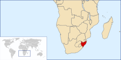
Die Kolonie Natal (Betonung auf der zweiten Silbe) war eine britische Kolonie im Süden Afrikas. Am 4. Mai 1843 annektierten die Briten die von burischen Siedlern gegründete Republik Natalia und erklärten das Gebiet zum Teil der Kapkolonie. 1856 wurde Natal eigenständige Kolonie, Hauptstadt war Pietermaritzburg. Von Natal aus wurde nach dem Zulukrieg 1879 auch das Königreich Zululand verwaltet. Im Jahre 1897 erfolgte die endgültige Angliederung Zululands an Natal, wodurch die Kolonie auf etwa das Doppelte der ursprünglichen Größe anwuchs.

Die Wirtschaft der Kolonie basierte hauptsächlich auf dem Anbau von Zuckerrohr, der über den Hafen Durban exportiert wurde. Da sich die einheimische Bevölkerung weigerte, auf den Zuckerrohrplantagen zu arbeiten, wurden ab 1860 in großem Umfang Arbeiter aus Britisch-Indien angeworben. Die indischstämmige Bevölkerung übertraf schon in den 1890er Jahren die Zahl der europäischen, darunter auch deutschstämmige Siedler. Heute existiert in Durban die größte indischstämmige Gemeinschaft einer Stadt außerhalb Indiens.
Zur Erforschung der geologischen Verhältnisse und der Bodenschätze errichtete die Regierung 1901 den Geological Survey of Natal and Zululand.
1910 wurde Natal mit der Kapkolonie, der Oranjefluss-Kolonie und der Transvaal-Kolonie zur Südafrikanischen Union vereinigt und bildete fortan die Provinz Natal (seit 1994 KwaZulu-Natal) in Südafrika.
Literatur
- Robert Russell: Natal. The Land and Its Story. J. M. Dent, London 1899 (archive.org).
- Robert James Mann: The Colony of Natal. An Account of the Characteristics and Capabilities of This British Dependency. Jarrold and Sons, London 1859 (archive.org).
- Joseph Forsyth Ingram: The Colony of Natal. An Official Illustrated Handbook and Railway Guide. J. Causton, London 1895 (archive.org).
- S. W. Silver & Co (Hrsg.): S. W. Silver and Company’s Handbook to South Africa. Including the Cape Colony, Natal, the Diamond Fields, the Transvaal, Orange Free State, etc. 3. überarbeitete Auflage. S.W. Silver, London 1880 (archive.org).
- John C. Noble (Hrsg.): Illustrated Official Handbook of the Cape and South Africa. A Résumé of the History, Conditions Populations, Productions and Resources of the Several Colonies, States an Territories. J. C. Juta, Kapstadt/Johannesburg 1893 (archive.org).
- Henry Brooks, Robert James Mann: Natal, a History and Description of the Colony. Including Its Natural Features, Productions, Industrial Condition and Prospects. L. Reeve, London 1876 (archive.org).
- William Clifford Holden: History of the colony of Natal, South Africa. A. Heylin, London 1855 (archive.org).
- Walter Peace: Our Colony of Natal. E. Stanford, London 1883.
- George McCall Theal: South Africa. The Cape Colony, Natal, Orange Free State South African Republic, Rhodesia, and all other Territories South of the Zambesi. G.P. Putnam’s Sons, New York 1900 (archive.org).
- Edgar Harry Brookes, Colin de B. Webb: A history of Natal. University of Natal Press, Pietermaritzburg 1965.
- George McCall Theal: History of South Africa Swan Sonnenschein, London
- Band 4. The Republics and Native Territories from 1854 to 1872. 1900, archive.org
- Band 5. From 1873 to 1884, Twelve Eventful Years, with Continuation of the History of Galekaland, Tembuland, Pondoland, and Bethshuanaland until the Annexation of those Territories to the Cape Colony, and of Zululand until its Annexation to Natal. 1919 Band 1, archive.org; Band 2, archive.org
Koordinaten: 30° S, 30° O
Auf dieser Seite verwendete Medien
Autor/Urheber: Seb az86556, Lizenz: CC BY 3.0
Location of the Natal Colony (British Empire), 1842-1910
Autor/Urheber: Sodacan, Lizenz: CC BY-SA 4.0
Flag of the Natal Colony 1875-1910
Autor/Urheber:
- SouthAfrica1885.jpg: John George Bartholomew
- derivative work: Themightyquill (talk)
Map of South Africa in July 1885, showing British possessions and protectorates, the two Boer Republics (i.e. Transvaal or SAR, and Orange Free State), besides German South West Africa and Portuguese Mozambique, or Province of Mozambique at the time
Autor/Urheber: Sodacan, Lizenz: CC BY-SA 4.0
Arms of the Natal Colony 1907-1997 copy


