Interstate 190 (New York)
| Interstate Highway 190 in den USA | ||||||||||||||||||||||||||||||||||||||||||||||||||||||||||||||||||||||||||||||||||||||||||||||||||||
 | ||||||||||||||||||||||||||||||||||||||||||||||||||||||||||||||||||||||||||||||||||||||||||||||||||||
| Karte | ||||||||||||||||||||||||||||||||||||||||||||||||||||||||||||||||||||||||||||||||||||||||||||||||||||
_map.svg) | ||||||||||||||||||||||||||||||||||||||||||||||||||||||||||||||||||||||||||||||||||||||||||||||||||||
| Basisdaten | ||||||||||||||||||||||||||||||||||||||||||||||||||||||||||||||||||||||||||||||||||||||||||||||||||||
| Betreiber: | ||||||||||||||||||||||||||||||||||||||||||||||||||||||||||||||||||||||||||||||||||||||||||||||||||||
| Gesamtlänge: | 45,61 km (28.3 mi) | |||||||||||||||||||||||||||||||||||||||||||||||||||||||||||||||||||||||||||||||||||||||||||||||||||
Straßenverlauf
| ||||||||||||||||||||||||||||||||||||||||||||||||||||||||||||||||||||||||||||||||||||||||||||||||||||
Die Interstate 190 in New York (kurz I-190) ist eine 45,61 km (28,3 mi) lange Autobahn in Buffalo. Sie führt von der Kreuzung mit der Interstate 90 bis zum Grenzübergang an der Lewiston–Queenston Bridge, die sich über den Niagara River streckt.
Geschichte
Der Teil der I-190 südlich des NY-384 in dem Ort Niagara Falls wurde ursprünglich von dem New York State Thruway Authority, als Teil des New York State Thruway Systems gebaut. Der Bau an zwei Segmenten, von der Ogden Street zur Porter Avenue im Zentrum von Buffalo und vom Beaver Island Parkway zur River Road auf Grand Island, begann in 1953. Auf Grand Island begann der Bau am 16. Juli 1954 um die beiden existierenden Brücken zu verbinden. Um 1955 begann die Konstruktion am Rest des Niagara Thruway. Am 14. August 1957 sollte die Strecke, die aktuell I-190 ist, eigentlich als I-90N ausgeschildert werden. Am 24. Februar 1959 wurde dann die I-90N zur I-190 umbenannt.[1]
Galerie
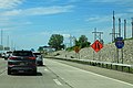 Schild an der I-190 N
 An der Ausfahrt 17 …
 … und 25b
Einzelnachweise
- ↑ American Association of State Highway and Transportation Officials. Abgerufen am 13. Mai 2022.
Auf dieser Seite verwendete Medien

Autobahnkreuz (Icon) in blau.


Wellenlinie als Gewässersymbol für die Formatvorlage Autobahn


.jpg)
Autor/Urheber: formulanone from Huntsville, United States, Lizenz: CC BY-SA 2.0
I-190 North - Exit 17 - NY266
.jpg)
Autor/Urheber: formulanone from Huntsville, United States, Lizenz: CC BY-SA 2.0
I-190 North Sign - MM17

600 mm × 600 mm (24 in × 24 in) U.S. Highway shield, made to the specifications of the 2004 edition of Standard Highway Signs. (Note that there is a missing "J" label on the left side of the diagram.) Uses the Roadgeek 2005 fonts. (United States law does not permit the copyrighting of typeface designs, and the fonts are meant to be copies of a U.S. Government-produced work anyway.)

Diagram of a 750 mm by 600 mm (30 in by 24 in) route marker for New York State Route 324, made to the specifications of the Manual on Uniform Traffic Control Devices (MUTCD), 2009 Edition (sign M1-5; p. 143) and the 2010 New York state supplement to the MUTCD (signs NYM3-1, NYM3-2, and NYM3-3; pp. 73, 256). Uses the Roadgeek 2005 fonts. (United States law does not permit the copyrighting of typeface designs, and the fonts are meant to be copies of a U.S. Government-produced work anyway.)

Diagram of a 750 mm by 600 mm (30 in by 24 in) route marker for New York State Route 265, made to the specifications of the Manual on Uniform Traffic Control Devices (MUTCD), 2009 Edition (sign M1-5; p. 143) and the 2010 New York state supplement to the MUTCD (signs NYM3-1, NYM3-2, and NYM3-3; pp. 73, 256). Uses the Roadgeek 2005 fonts. (United States law does not permit the copyrighting of typeface designs, and the fonts are meant to be copies of a U.S. Government-produced work anyway.)


Diagram of a 750 mm by 600 mm (30 in by 24 in) route marker for New York State Route 198, made to the specifications of the Manual on Uniform Traffic Control Devices (MUTCD), 2009 Edition (sign M1-5; p. 143) and the 2010 New York state supplement to the MUTCD (signs NYM3-1, NYM3-2, and NYM3-3; pp. 73, 256). Uses the Roadgeek 2005 fonts. (United States law does not permit the copyrighting of typeface designs, and the fonts are meant to be copies of a U.S. Government-produced work anyway.)


Diagram of a 750 mm by 600 mm (30 in by 24 in) route marker for New York State Route 266, made to the specifications of the Manual on Uniform Traffic Control Devices (MUTCD), 2009 Edition (sign M1-5; p. 143) and the 2010 New York state supplement to the MUTCD (signs NYM3-1, NYM3-2, and NYM3-3; pp. 73, 256). Uses the Roadgeek 2005 fonts. (United States law does not permit the copyrighting of typeface designs, and the fonts are meant to be copies of a U.S. Government-produced work anyway.)

Diagram of a 750 mm by 600 mm (30 in by 24 in) route marker for New York State Route 354, made to the specifications of the Manual on Uniform Traffic Control Devices (MUTCD), 2009 Edition (sign M1-5; p. 143) and the 2010 New York state supplement to the MUTCD (signs NYM3-1, NYM3-2, and NYM3-3; pp. 73, 256). Uses the Roadgeek 2005 fonts. (United States law does not permit the copyrighting of typeface designs, and the fonts are meant to be copies of a U.S. Government-produced work anyway.)
.jpg)
Autor/Urheber: formulanone from Huntsville, United States, Lizenz: CC BY-SA 2.0
I-190 North - Exit25B - NY104 - Last US Exit

Diagram of a 750 mm by 600 mm (30 in by 24 in) route marker for New York State Route 104, made to the specifications of the Manual on Uniform Traffic Control Devices (MUTCD), 2009 Edition (sign M1-5; p. 143) and the 2010 New York state supplement to the MUTCD (signs NYM3-1, NYM3-2, and NYM3-3; pp. 73, 256). Uses the Roadgeek 2005 fonts. (United States law does not permit the copyrighting of typeface designs, and the fonts are meant to be copies of a U.S. Government-produced work anyway.)