Interstate 105 (Kalifornien)
| Interstate Highway 105 in den USA | |||||||||||||||||||||||||||||||||||||||||||||||||||||||||||||||||||||||||||||||||||||
| Glenn Anderson Freeway | |||||||||||||||||||||||||||||||||||||||||||||||||||||||||||||||||||||||||||||||||||||
 | |||||||||||||||||||||||||||||||||||||||||||||||||||||||||||||||||||||||||||||||||||||
| Karte | |||||||||||||||||||||||||||||||||||||||||||||||||||||||||||||||||||||||||||||||||||||
 | |||||||||||||||||||||||||||||||||||||||||||||||||||||||||||||||||||||||||||||||||||||
| Basisdaten | |||||||||||||||||||||||||||||||||||||||||||||||||||||||||||||||||||||||||||||||||||||
| Betreiber: | |||||||||||||||||||||||||||||||||||||||||||||||||||||||||||||||||||||||||||||||||||||
| Gesamtlänge: | 30,29 km (18.8 mi) | ||||||||||||||||||||||||||||||||||||||||||||||||||||||||||||||||||||||||||||||||||||
Straßenverlauf
| |||||||||||||||||||||||||||||||||||||||||||||||||||||||||||||||||||||||||||||||||||||
Die Interstate 105 (Abkürzung I-105), auch Glenn Anderson Freeway, ist ein Interstate Highway im Los Angeles County im US-Bundesstaat Kalifornien.
Verlauf
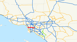
Die Interstate 105 beginnt am Sepulveda Boulevard (California State Route 1) in El Segundo. Von dort aus führt er nach Osten über die Flüsse Los Angeles River und San Gabriel River. Die Interstate endet in Norwalk an der Interstate 605. Sie kreuzt in Inglewood mit der Interstate 405 und in Lynwood mit der Interstate 710. Das Kreuz mit der Interstate 110 trägt den Namen Judge Harry Pregerson Interchange. Im Mittelstreifen der Autobahn verlaufen die Gleise der Green Line, einer Stadtbahnlinie der Metro Los Angeles.
Weblinks
- California @ AA Roads Streckenbeschreibung mit Fotos (englisch)
- Los Angeles Freeways (englisch)
Auf dieser Seite verwendete Medien
Autobahnkreuz (Icon) in blau.
600 mm by 300 mm (24 in by 12 in) south plate with small letters, made to the specifications of the 2004 edition of Standard Highway Signs (sign M3-3). Uses the Roadgeek 2005 fonts. (United States law does not permit the copyrighting of typeface designs, and the fonts are meant to be copies of a U.S. Government-produced work anyway.) Colors are from [1] (Pantone Green 342), converted to RGB by [2]. The outside border has a width of 1 (1 mm) and a color of black so it shows up; in reality, signs have no outside border.
Zeichen 253 – Verbot für Kraftfahrzeuge mit einem zulässigen Gesamtgewicht über 2,8 t (später 3,5 t), einschließlich ihrer Anhänger, und Zugmaschinen, ausgenommen Personenkraftwagen und Kraftomnibusse. Das Zeichen wurde mit diesem Sinnbild am 1. Juli 1992 eingeführt. Es ist in den Größen 420x420, 600x600 sowie 750x750 mm erhältlich. Bei einem 600x600 mm großen Zeichen ist die Lichtkantenbreite 10 mm breit, der innere weiße Bereich hat eine Breite von 420 mm und die rote Umrandung 80 mm stark.
600 mm by 300 mm (24 in by 12 in) north plate with small letters, made to the specifications of the 2004 edition of Standard Highway Signs (sign M3-1). Uses the Roadgeek 2005 fonts. (United States law does not permit the copyrighting of typeface designs, and the fonts are meant to be copies of a U.S. Government-produced work anyway.) Colors are from [1] (Pantone Green 342), converted to RGB by [2]. The outside border has a width of 1 (1 mm) and a color of black so it shows up; in reality, signs have no outside border.
Nach links zeigendes schwarzes Dreieck ◀, U+25C0 aus dem Unicode-Block Geometrische Formen (25A0–25FF)
Vector image of a 24 in by 25 in (600 mm by 635 mm) California State Route shield. Colors are from [1] (Pantone Green 342), converted to RGB by [2]. The outside border has a width of 1 (1/16 in) and a color of black so it shows up; in reality, signs have no outside border.
The California State Route shield for California State Route 1 — Pacific Coast Highway — Highway 1, among others, along the California Coast.
Flag of California. This version is designed to accurately depict the standard print of the bear as well as adhere to the official flag code regarding the size, position and proportion of the bear, the colors of the flag, and the position and size of the star.
Nach rechts zeigendes schwarzes Dreieck ▶, U+25B6 aus dem Unicode-Block Geometrische Formen (25A0–25FF)
This is a map of Interstate 105 in California, with unconstructed parts in purple.


