Gravity Recovery and Interior Laboratory
| Gravity Recovery and Interior Laboratory | |||||||||||||||||||
|---|---|---|---|---|---|---|---|---|---|---|---|---|---|---|---|---|---|---|---|
Missionslogo | |||||||||||||||||||
| Typ | Raumsondenpaar | ||||||||||||||||||
| Land | |||||||||||||||||||
| Organisation | |||||||||||||||||||
| COSPAR-Bezeichnung | 2011-046A 2011-046B | ||||||||||||||||||
| Missionsdaten | |||||||||||||||||||
| Startdatum | 10. September 2011, 13:08:52 UTC | ||||||||||||||||||
| Startplatz | Cape Canaveral AFS, LC-17B | ||||||||||||||||||
| Trägerrakete | Delta-7920H-10C | ||||||||||||||||||
| Missionsdauer | 464 Tage | ||||||||||||||||||
| Enddatum | 17. Dezember 2012, 22:29:21 UTC | ||||||||||||||||||
| Landeplatz | kontrollierter Absturz in Nordpolregion (an unbenanntem Berg zerschellt) | ||||||||||||||||||
| Bahndaten | |||||||||||||||||||
| Koordinatenursprung | Mond | ||||||||||||||||||
| Bahnhöhe | 55 km (anfänglich) | ||||||||||||||||||
| Umlaufzeit | 113 min (anfänglich) | ||||||||||||||||||
| Allgemeine Raumfahrzeugdaten | |||||||||||||||||||
| Startmasse | jeweils 307 kg | ||||||||||||||||||
| Leermasse | jeweils 201 kg | ||||||||||||||||||
| Abmessungen | (H × B × T) 109 cm × 95 cm × 76 cm | ||||||||||||||||||
| Hersteller | Lockheed Martin Space Systems | ||||||||||||||||||
| Sonstiges | |||||||||||||||||||
| Vorherige Mission | Kepler | ||||||||||||||||||
| Nachfolgende Mission | InSight | ||||||||||||||||||
| |||||||||||||||||||
Gravity Recovery and Interior Laboratory (GRAIL) war eine Mondmission der NASA, die im Rahmen des Discovery-Programms durchgeführt wurde. Der Name spielt auf engl. (Holy) Grail = (Heiliger) Gral an.
GRAIL bestand aus zwei im September 2011 gemeinsam gestarteten Raumsonden, die zwischen Anfang 2012 und Dezember 2012 den Mond umkreisten. Ziel der Mission war die genaue Vermessung des lunaren Schwerefelds und der Schwereanomalien, um daraus Aufschlüsse auf den inneren Aufbau des Mondes zu gewinnen.
Aufbau der Sonden
Die Mission wurde vom Jet Propulsion Laboratory geleitet. Die Sonden wurden von Lockheed Martin Space Systems basierend auf dem XSS-11-Satelliten gebaut.[1] Die Stromversorgung erfolgte über zwei ausklappbare, aber nicht schwenkbare Solarmodule (763 W), die Lithium-Ionen-Akkumulatoren aufluden (30 Ah bei 28 V).[2] Zur Lageregelung dienten Warmgas-Steuerdüsen und Reaktionsschwungräder. Die Daten wurden über eine S-Band-Funkverbindung an das Deep Space Network (DSN) übertragen.[3]
Die Sonden arbeiteten, wie die GRACE-Satelliten, nach dem SST-Prinzip (Satellite-to-Satellite Tracking): Sie umrundeten den Mond auf derselben Bahn und maßen mit dem Lunar Gravity Ranging System (LGRS) mittels elektromagnetischer Wellen im Ka-Band kontinuierlich die gegenseitige Distanz. Dadurch ließen sich Unregelmäßigkeiten des Schwerefeldes mit hoher Präzision analysieren.[3]
Als zusätzliche Nutzlast, zu Bildungszwecken für Schüler, befand sich auf jeder der beiden Sonden das Kamerasystem E/PO MoonKam mit jeweils fünf einzelnen Kameras, die Bilder von der Mondoberfläche, der Erde und den Sonden selbst übermittelten.[4] Die Sonden wurde nach einem landesweiten Wettbewerb für Schulklassen „Ebb“ (Ebbe) und „Flow“ (Flut) benannt.[5]

Missionsverlauf
Die beiden GRAIL-Sonden starteten zusammen auf einer zweistufigen Delta-7920H-10C-Rakete am 10. September 2011 um 13:08:52 UTC von der Cape Canaveral Air Force Station aus.
Nach dem Start erfolgte eine dreieinhalbmonatige Transferphase über den Lagrange-Punkt L1 des Erde-Sonne-Systems zum Mond, um die erforderliche Geschwindigkeitsänderung klein zu halten und andererseits die sehr niedrige Mondumlaufbahn von nur etwa 50 km Höhe möglichst exakt zu erreichen. Die Umlaufzeit der Sonden um den Mond betrug 113 Minuten. Auf dieser Höhe folgten die beiden Satelliten einander in 175 bis 225 Kilometer Abstand.[6]

Die eigentliche Wissenschaftsmission begann am 7. März 2012[7] und hatte eine Dauer von 82 Tagen. Diese war in drei Zyklen von je 27,3 Tagen gegliedert. Zweimal täglich standen die Sonden für je 8 Stunden mit dem Deep Space Network (DSN) in Verbindung und übertrugen ihre gesammelten Daten.[6]
Nach Abschluss der primären Wissenschaftsphase wurde eine Verlängerung der Mission beschlossen, die vom 30. August bis 3. Dezember 2012 andauern sollte. Dafür verringerten die Sonden ihre Höhe auf durchschnittlich 23 Kilometer, um noch detailliertere Messungen durchführen zu können.[8] Nach Ende der Mission im Dezember 2012 erfolgte eine fünftägige Außerdienststellungsphase, nach der die beiden Satelliten später auf dem Mond aufschlagen sollten, um einen unkontrollierten Absturz auf eventuell bedeutsame Stätten wie z. B. die Apollo-Landestellen zu vermeiden.[6]
Beide Raumsonden kollidierten zum planmäßigen Missionsende am 17. Dezember 2012 mit einem unbenannten Berg zwischen Philolaus und Mouchez nahe dem Mondnordpol. Um 22:28:51 UTC schlug GRAIL A („Ebb“) zuerst auf der Mondoberfläche auf, eine halbe Minute später folgte GRAIL B („Flow“). Der Ort des Einschlags beider Satelliten wurde von der NASA nach der 2012 verstorbenen Astronautin Sally Ride benannt.[9]
 Die GRAIL-Sonden bei der Startvorbereitung
 Die GRAIL-Sonden auf der Trägerrakete
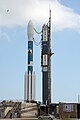 Die Delta-7920H-10C vor dem Start
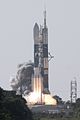 Die Delta 7920H-10C kurz vor dem Abheben
 Dicke der Mondkruste
Weblinks
- GRAIL@ nasa.gov, abgerufen am 1. Januar 2012
- MIT GRAIL Home Page
- NASA News: New NASA Mission to Reveal Moon's Internal Structure and Evolution, 11. Dezember 2007 (englisch)
- Kennedy Space Center: Medienarchiv zur GRAIL-Mission
- hda: Nasa-Mission, Sonden-Duo soll Rätsel um zweiten Erdmond lösen, in Spiegel Online Datum: 7. September 2011, abgerufen: 10. September 2011
- NASA: GRAIL-A erreicht Mond am 31. Dezember 2011
Videos
- Parting Moon Shots from NASA's GRAIL mission. Aufnahmen der Mondrückseite im Dezember 2012, JPLnews@youtube, abgerufen am 16. Januar 2013
Einzelnachweise
- ↑ Lockheed Martin spacecraft to be flown for NASA’s GRAIL lunar mission ( vom 29. Dezember 2007 im Internet Archive)
- ↑ NASA: Gravity Recovery and Interior Laboratory (GRAIL) Launch Kit (PDF; 1,2 MB)
- ↑ a b GRAIL: Spacecraft & Payload. MIT, abgerufen am 5. September 2011.
- ↑ GRAIL: Education & Outreach. MIT, abgerufen am 5. September 2011.
- ↑ NASA: Montana Students Submit Winning Names for NASA Lunar Spacecraft, vom 17. Januar 2012
- ↑ a b c GRAIL: Mission Design. MIT, abgerufen am 5. September 2011.
- ↑ NASA: NASA's Twin GRAIL Spacecraft Begin Collecting Lunar Science Data
- ↑ NASA: NASA's GRAIL Moon Twins Begin Extended Mission Science, vom 31. August 2012
- ↑ NASA: NASA's GRAIL Lunar Impact Site Named for Astronaut Sally Ride, vom 17. Dezember 2012
NEAR Shoemaker (1996) • Mars Pathfinder (1996) • Lunar Prospector (1998) • Stardust (1999) • Genesis (2001) • CONTOUR (2002) • MESSENGER (2004) • Deep Impact (2005) • Dawn (2007) • Kepler (2009) • GRAIL (2011) • InSight (2018) • Lucy (2021) • Psyche (2023)
Geplant: Davinci (2028–2030)
Zurückgestellt: Veritas
Kursiv geschriebene Missionen sind aktiv.
Auf dieser Seite verwendete Medien


Icon für eine vertikale Zeitleiste
The figure shows GRAIL-A and GRAIL-B trajectories for a launch at the open and close of the launch period.
The low-energy trajectories leave Earth following a path towards the sun, passing near the interior Sun-Earth
Lagrange Point 1 (Earth Libration Point 1) before heading back towards the Earth-moon system.
Technicians Get GRAIL Spacecraft Ready for Launch The Gravity Recovery And Interior Laboratory (GRAIL) mission utilizes the technique of twin spacecraft flying in formation with a known altitude above the lunar surface and known separation distance to investigate the gravity field of the moon in unprecedented detail. The technique utilizes radio links between the two spacecraft as well as radio links to stations on Earth. The mission also will answer longstanding questions about Earth's moon, including a possible inner core, and provide scientists with a better understanding of how Earth and other rocky planets in the solar system formed. GRAIL is a part of NASA's Discovery Program.
The Lunar Gravity Ranging System (LGRS) is the scientific payload of the GRAIL lunar spacecraft. The LGRS is responsible for sending and receiving the signals needed to accurately and precisely measure the changes in range between the two orbiters. The LGRS consists of an Ultra-Stable Oscillator (USO), Microwave Assembly (MWA), a Time-Transfer Assembly (TTA), and the Gravity Recovery Processor Assembly (GPA). The USO provides a steady reference signal that is used by all of the instrument subsystems. Within the LGRS, the USO provides the reference frequency for the MWA and the TTA. The MWA converts the USO reference signal to the Ka-band frequency, which is transmitted to the other orbiter. The function of the TTA is to provide a two-way time-transfer link between the spacecraft to both synchronize and measure the clock offset between the two LGRS clocks. The TTA generates an S-band signal from the USO reference frequency and sends a GPS-like ranging code to the other spacecraft. The GPA combines all the inputs received from the MWA and TTA to produce the radiometric data that is downlinked to the ground. In addition to acquiring the inter-spacecraft measurements, the LGRS also provides a one-way signal to the ground based on the USO, and is transmitted via the X-band Radio Science Beacon (RSB). The steady-state drift of the USO is measured via the one-way Doppler data provided by the RSB.

Icon für eine vertikale Zeitleiste
This map shows the gravity field of the moon as measured by NASA's GRAIL mission. The viewing perspective, known as a Mercator projection, shows the far side of the moon in the center and the nearside (as viewed from Earth) at either side. Units are milliGalileos where 1 Galileo is 1 centimeter per second squared. Reds correspond to mass excesses which create areas of higher local gravity, and blues correspond to mass deficits which create areas of lower local gravity.
GRAIL mission logo.
.jpg)
CAPE CANAVERAL, Fla. – The United Launch Alliance Delta II Heavy rocket lifted off at 9:08 a.m. EDT Sept. 10 from Space Launch Complex 17B on Cape Canaveral Air Force Station in Florida carrying NASA’s twin Gravity Recovery and Interior Laboratory (GRAIL) mission to the moon.

CAPE CANAVERAL, Fla. -- At Space Launch Complex 17B on Cape Canaveral Air Force Station in Florida, NASA's twin Gravity Recovery and Interior Laboratory spacecraft are secured atop a Delta II rocket awaiting enclosure in the Delta payload fairing. The fairing will protect the spacecraft from the impact of aerodynamic pressure and heating during ascent and will be jettisoned once the spacecraft is outside the Earth's atmosphere. Launch aboard a United Launch Alliance Delta II rocket from Pad 17B is scheduled for Sept. 8. The spacecraft will fly in tandem orbits around the moon for several months to measure its gravity field. GRAIL's primary science objectives are to determine the structure of the lunar interior, from crust to core, and to advance understanding of the thermal evolution of the moon. For more information, visit http://www.nasa.gov/grail.

Header of the Discovery program's official website, from January 2016.

Icon für eine vertikale Zeitleiste

This image depicting the crustal thickness of the moon was derived using gravity data from NASA's GRAIL mission and topography data from NASA's Lunar Reconnaissance Orbiter. The measurements match those found from seismic data at the NASA Apollo mission 12 and 14 landing sites, where crustal thickness is 19 miles (30 kilometres). There is a minimum crustal thickness less than 0.6 mile (1 kilometre) within the nearside Crisium and far side Moscoviense impact basins. The average thickness of the crust is 21 miles (34 kilometers), which is almost 12 miles (20 kilometres) thinner than values from previous studies. Regions of crustal thinning in blue are associated with several large impact basins several hundreds of kilometres in diameter. The far side differs from the near side by having a higher than average crustal thickness (in red).

CAPE CANAVERAL, Fla. – At Space Launch Complex 17B on Cape Canaveral Air Force Station, the United Launch Alliance Delta II heavy rocket that will launch NASA's Gravity Recovery and Interior Laboratory spacecraft is rolled back around to the mobile service tower after the first launch attempt was scrubbed due to upper-level winds. GRAIL is scheduled for another launch attempt Sept.10 at 8:29:45 a.m. EDT. GRAIL will fly twin spacecraft in tandem around the moon to precisely measure and map variations in the moon's gravitational field. The mission will provide the most accurate global gravity field to date for any planet, including Earth. This detailed information will reveal differences in the density of the moon's crust and mantle and will help answer fundamental questions about the moon's internal structure, thermal evolution, and history of collisions with asteroids. The aim is to map the moon's gravity field so completely that future moon vehicles can safely navigate anywhere on the moon’s surface. For more information, visit http://www.nasa.gov/grail.