Ganges Chasma
| Grabenbruch auf dem Mars | ||
|---|---|---|
| Ganges Chasma | ||
 | ||
| Links: eine Klippe am Nordrand, auf einer Aufnahme von THEMIS; rechts: topografische Übersicht mit linkem Ausschnitt in rotem Rahmen | ||
| ||
| Position | 8° S, 48° W | |
| Ausdehnung | 584 km | |
| Region | Xanthe Terra | |
| Geschichte | ||
| Benannt nach | Ganges | |
Ganges Chasma ist ein tiefer Canyon auf dem Mars. Er wurde 1973 nach dem Ganges in Südasien benannt.[1]
Beschreibung
Ganges Chasma befindet sich im Süden des Hochlands Xanthe Terra, am östlichen Ende des ausgedehnten Systems der Vallis Marineris. Die Schlucht ist 584 km lang und enthält die 136 km weite Hochfläche Ganges Mensa.[2] Im Osten des Chasma schließt sich Capri Chasma an. Es wird davon ausgegangen, dass sich Ganges Chasma durch eine Abfolge großer Ausflüsse von Wasser und CO2 aus chaotischen Terrain wie Ganges Chaos im Süden gebildet hat.[3] Zusätzlich wird davon ausgegangen, dass die meisten Hinweise darauf ausgewaschen wurden.[3] Zuerst entwickelte sich ein Ausläufer, der sich mit Capri Chasma und den verbundenen Ausflusskanälen im Osten verband. Zwischenzeitlich, während der Noachischen Periode, bestand möglicherweise ein See mit Abfluss nach Norden, teilweise unterirdisch im Shalbatana Vallis.[4]
Detailgalerie
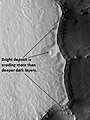
Helle, erodiertere Ablagerungen auf dunkleren Schichten

Sedimentschichten am oberen Hang in höherer Bildauflösung

Erdrutsch am Nordwesthang

„Staubteufel“ im Ganges Chasma
Einzelnachweise
- ↑ Ganges Chasma im Gazetteer of Planetary Nomenclature der IAU (WGPSN) / USGS
- ↑ Ganges Mensa im Gazetteer of Planetary Nomenclature der IAU (WGPSN) / USGS
- ↑ a b J. A. P. Rodriguez, J. Kargel, D. A. Crown, L. F. Bleamaster, K. L. Tanaka, V. Baker, H. Miyamoto, J. M. Dohm, S. Sasaki, G. Komatsu: Headward growth of chasmata by volatile outbursts, collapse, and drainage: Evidence from Ganges chaos, Mars. In: Geophysical Research Letters. 33, Nr. 18, September 2006, ISSN 0094-8276. doi:10.1029/2006GL026275.
- ↑ J. A. P. Rodriguez, S. Sasaki, H. Miyamoto: Nature and hydrological relevance of the Shalbatana complex underground cavernous system. In: Geophysical Research Letters. 30, Nr. 6, 2003, ISSN 0094-8276. doi:10.1029/2002GL016547.
Auf dieser Seite verwendete Medien

Carte de Mars reconstituée à partir des mesures de Mars Global Surveyor (MOLA) et des observations de Viking.

This is a daytime IR image of a chaos region within Xanthe Terra. As with earlier images, the landslide in this image is caused by the failure of steep slopes releasing material to form the landslide deposit.
Ganges Chasma, as seen by THEMIS. The location is 6.4 degrees south latitude and 310.7 degrees east longitude. Image is about 18 km wide.

HiRise looked at a small section of Ganges Chasma, which is a trough that makes up part of Valles Marineris. The image is just stunning. Long ago, the surface of Mars in this region was flooded by lava flows. After that, time and wind began changing the surface. Windblown dust and sand covered up everything. If you click on the image and examine the larger version more closely, particularly the region near the edge of this chasm, it looks brighter and smoother than the lava flows underneath. Could this be sediments put in place by flowing water? Or did an explosive v0lcanic event layer the region with fine dust? Or, was it the work of the incessantly blowing Martian winds depositing layer upon layer of fine dust? A combination of all these factors?

Ganges Chasma Layers, as seen by hirise. Location is 8.1 degrees south latitude and 307.5 degrees east longitude. Image was taken by the Mars Reconnaissance Orbiter's HiRISE. The HiRISE camera was built by Ball Aerospace and Technology orporation and is operated by the University of Arizona. Image courtesy NASA/JPL/University of Arizona.

PIA20045: Marching Dust Devils
http://photojournal.jpl.nasa.gov/catalog/PIA20045
On an early fall afternoon in Ganges Chasma (Valles Marineris), we managed to capture a cluster of eight dust devils, five of them in the enhanced color strip. They're together on a dark sandy surface that tilts slightly to the north, towards the Sun.
Both of these factors help warm the surface and generate convection in the air above. The surface is streaked with the faint tracks of earlier dust devils. A pair of dust devils appears together at top right, spaced only 250 meters apart. These two have quite different morphologies. The bigger one (on the right) is about 100 meters in diameter and is shaped like a doughnut with a hole in the middle. Its smaller companion is more compact and plume-like, but it too has a small hole in the center, where the air pressure is lowest. It may be that the smaller dust devil is younger than the larger one. A row of four dust devils are in the middle of the color strip, separated by about 900 meters from one another.
This image might answer some interesting questions about the behavior of dust devils. Dust devils are theoretically expected to migrate uphill on a sloping surface, or migrate downwind when there is a breeze. Where they are found close together in pairs, they are expected to rotate in opposite directions. HiRISE color observations can be used to determine the direction of rotation and-for fast moving dust devils-the direction of their travel. This is because the different color observations (infrared, red, and blue) are taken at slightly different times. The differences between the earliest color observation and the last tell us about the changes that took place during that time interval.
All this requires careful analysis, but if these dust devils are moving fast enough, and spaced closely enough, these here might display some interesting "social dynamics," possibly marching together and rotating in alternating directions.
The University of Arizona, Tucson, operates HiRISE, which was built by Ball Aerospace & Technologies Corp., Boulder, Colo. NASA's Jet Propulsion Laboratory, a division of the California Institute of Technology in Pasadena, manages the Mars Reconnaissance Orbiter Project for NASA's Science Mission Directorate, Washington.