Flugplatz Bad Ragaz
| Flugplatz Bad Ragaz | ||||
|---|---|---|---|---|
 | ||||
| Kenndaten | ||||
| ICAO-Code | LSZE | |||
| Koordinaten | ||||
| Höhe über MSL | 493 m (1.617 ft) | |||
| Verkehrsanbindung | ||||
| Entfernung vom Stadtzentrum | 2 km nordwestlich von Bad Ragaz | |||
| Basisdaten | ||||
| Betreiber | Docair AG | |||
| Start- und Landebahn | ||||
| 12/30 | 495 m × 11 m Asphalt | |||
Der Flugplatz Bad Ragaz liegt etwa zwei Kilometer vom Dorfzentrum Bad Ragaz entfernt. Der Flugplatz liegt auf einer Höhe von 493 m/AMSL (1617 feet/AMSL) und ist 14 km von Vaduz bzw. 18 km von Chur entfernt.
Der Flugplatz hat eine Asphaltpiste (Runway 30/12), die 495 Meter lang und 12 Meter breit ist. Beim Flugplatz Bad Ragaz handelt es sich um einen Privat-Flugplatz (PPR). Er ist an Feiertagen gesperrt. Am Flugplatz sind die Segelfluggruppe Bad Ragaz und die Motorfluggruppe Chur ansässig.
 Flugplatz Bad Ragaz
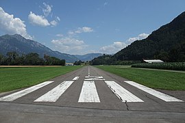 Start- und Landebahn
 Bo208C HB-UXP 70 in 1970
Weblinks
Ambrì • Amlikon • Bad Ragaz • Bellechasse • Bex • Biel-Kappelen • Buochs • Buttwil • Courtelary • Dittingen • Fricktal-Schupfart • Gruyères • Hausen am Albis • Kägiswil • La Côte • Langenthal • Locarno • Lommis • Luzern-Beromünster • Mollis • Montricher • Môtiers • Münster • Neuchâtel • Olten • Raron • Reichenbach • Saanen • Schaffhausen • Schänis • Sitterdorf • Speck-Fehraltorf • St. Stephan • Thun • Triengen • Wangen-Lachen • Winterthur • Yverdon-les-Bains • Zweisimmen
Auf dieser Seite verwendete Medien

(c) Karte: NordNordWest, Lizenz: Creative Commons by-sa-3.0 de
Positionskarte der Schweiz (Confoederatio Helvetica)

Die quadratische Nationalfahne der Schweiz, in transparentem rechteckigem (2:3) Feld.

Autor/Urheber: Aviationem, Lizenz: CC BY-SA 4.0
Mooney M20R Ovation HB-DIE (Motorfluggruppe Chur), Flugplatz Bad Ragaz
.jpg)
Autor/Urheber: Kecko from Switzerland (Rheintal SG, the border valley between Switzerland and Austria), Lizenz: CC BY 2.0
Bad Ragaz is a rather small private airfield for motor flight and gliding. The concrete runway has a length of 495 m (1624 ft) and is situated at an altitude of 493 m ASL (1617 ft). Once a year, during the World Economic Forum (WEF) in Davos, special rules are in force. The airfield is located then in a restricted and by the military controlled zone (R-Area). Flying in this time is possible only for local aircrafts, according to a specific and confidential procedure, agreed with the army. This includes among others the radio frequency of the airforce radar, transponder code and a mission number. If the rules are not adhered to exactly, it will activate a 'hot mission' by the airforce. Switzerland, July 24, 2012.


Autor/Urheber: Chriusha, Lizenz: CC BY-SA 3.0
Bölkow 208 C Junior HB-UXP der Motorfluggruppe Chur auf dem Flugplatz Bad Ragaz (LSZE)
Autor/Urheber: Carsten Steger, Lizenz: CC BY-SA 4.0
Luftbild des Flugplatzes Bad Ragaz