Fiddler’s Island
| Fiddler’s Island | ||
|---|---|---|
 (c) Steve Daniels, CC BY-SA 2.0 | ||
| Gewässer | Themse | |
| Geographische Lage | 51° 46′ N, 1° 17′ W | |
| ||
| Einwohner | unbewohnt | |
.svg)
Fiddler’s Island ist eine Insel im Fluss Themse bei Oxford in England. Die Insel liegt südlich von Port Meadow im Flussabschnitt oberhalb des Osney Lock.
Die Nordseite der Insel liegt zwischen der Themse und dem oberen Ende des Castle Mill Stream, einem Altwasserarm der Themse. Fiddler’s Island Stream fließt auf der Ostseite des südlichen Endes der Insel. Im Süden der Insel ist ein kurzer Abschnitt, der als Sheepwash Channel eine Verbindung zum Castle Mill Stream dem Oxford-Kanal herstellt.[2]
Der Themsepfad läuft die gesamte Länge der Insel entlang. Auf der Seite des Castle Mill Stream gibt es zahlreiche Bootsanleger. Die regenbogenförmige Medley Footbridge überquert den Hauptarm des Flusses nach Westen an der Nordseite und eine flache eiserne Bailey-Brücke überquert den Castle Mill Stream weiter südlich und stellt eine Verbindung mit Port Meadow im Osten her. Eine schmale Fußgängerbrücke führt den Themsepfad am Ufer nach Osney Bridge. Das Nordende von Fiddler’s Island ist sehr schmal. Das Südende mit der Brücke ist wesentlich breiter.
Östlich der Insel liegt Cripley Meadow, ein Gebiet, das größtenteils aus Kleingärten besteht.
Das Baden auf Fiddler’s Island wurde 1852 von der Gemeinde Oxford als wahrscheinlich dem ersten Platz in der Gemeinde erlaubt.[3]
Galerie
 Der nördliche Teil der Insel
 (c) Steve Daniels, CC BY-SA 2.0Bootsanleger
im Castle Mill Stream (c) Steve Daniels, CC BY-SA 2.0Der Themsepfad auf Fiddler’s Island in Blickrichtung Norden
 (c) Derek Harper, CC BY-SA 2.0Blick nach Süden entlang des Themsepfad
 (c) Steve Daniels, CC BY-SA 2.0Die Bailey-Brücke von Port Meadow nach Fiddler’s Island
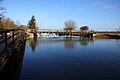 (c) Steve Daniels, CC BY-SA 2.0Blick nach Norden mit Port Meadow rechts im Bild
Siehe auch
Weblinks
Einzelnachweise
- ↑ Oxford to Northmoor. In: The Thames Path National Trail UK. Abgerufen am 18. September 2012.
- ↑ River Thames (Sheepwash Channel). CanalPlanAC UK, abgerufen am 15. September 2012.
- ↑ Eleanor Chance, Christina Colvin, Janet Cooper, C J Day, T G Hassall, Mary Jessup, Nesta Selwyn: Non-Christian Religious Bodies. In: Alan Crossley, C. R. Elrington (Hrsg.): A History of the County of Oxford. Band 4: The City of Oxford. British History Online, London 1979, S. 428 (englisch, british-history.ac.uk [abgerufen am 25. März 2017]).
Auf dieser Seite verwendete Medien

(c) Steve Daniels, CC BY-SA 2.0
Left:Rainbow Bridge or Rainbow Footbridge.
Centre (foreground): The Thames Path footbridge across narrow islands including Fiddler's Island.
Right: Tank Bridge or Tank Footbridge

Contains Ordnance Survey data © Crown copyright and database right, CC BY-SA 3.0
Map of Oxfordshire, UK with districts shown.
Equirectangular map projection on WGS 84 datum, with N/S stretched 160%
Geographic limits:
- West: 1.74W
- East: 0.72W
- North: 52.19N
- South: 51.44N

(c) Derek Harper, CC BY-SA 2.0
Fiddler's Island Seen from the footbridge across Castlemill Stream, which runs to the left of the island. On the right is the Thames.

(c) Steve Daniels, CC BY-SA 2.0
Moorings on Fiddler's Island Stream
(c) Steve Daniels, CC BY-SA 2.0
The Thames Path on Fiddler's Island

(c) Steve Daniels, CC BY-SA 2.0
Bridge over Fiddler's Island Stream

(c) Steve Daniels, CC BY-SA 2.0
Bridge over Fiddler's Island Stream, an exact half-section of the Thames so as it is paired with a further bridge over the other half, is fairly considered one half of a full Thames bridge.