East of England
| East of England | |
|---|---|
 | |
| Geografie | |
| Fläche | 19.120 km² |
| Verwaltungssitz | Flempton |
| Demografie | |
| Bevölkerung Bevölkerungsdichte | 5.907.348 (2012)[1] 309 Einwohner/km² |
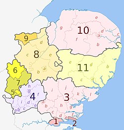
East of England ist eine der neun Regionen Englands. Zu ihr gehören die folgenden Grafschaften (counties) und Unitary Authorities:
| Die Region besteht aus fünf Countys und den sechs Unitary Authorities |
Siehe auch: Verwaltungsgliederung Englands
Wirtschaft
Im Vergleich mit dem BIP der EU ausgedrückt in Kaufkraftstandards erreicht die Region einen Index von 101 (EU-28=100) (2015).[2]
Weblinks
- Government Office for the East of England (Memento vom 16. November 2010 im Internet Archive)
Einzelnachweise
- ↑ Bevölkerung von England und Wales am 30. Juni 2012 (ZIP; 832 kB)
- ↑ Eurostat. Abgerufen am 22. August 2018.
Koordinaten: 52° 15′ N, 0° 33′ O
Auf dieser Seite verwendete Medien
The Equalizer, Dr Greg and Nilfanion. Contains Ordnance Survey data © Crown copyright and database right 2010, CC BY-SA 3.0
Map of the East of England region, showing its counties and administrative districts. The county colours are the same as those in File:English metropolitan and non-metropolitan counties 2009.svg.
Equirectangular map projection on WGS 84 datum, with N/S stretched 160%
Geographic limits:
- West: 0.8W
- East: 1.8E
- North: 53.1N
- South: 51.4N
Autor/Urheber: TUBS
Lage der Region XY (siehe Dateiname) in England.


