East Wallabi Island
| East Wallabi Island | ||
|---|---|---|
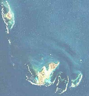
 East Wallabi etwa in der Bildmitte. East Wallabi etwa in der Bildmitte. | ||
| Gewässer | Indischer Ozean | |
| Inselgruppe | Wallabi-Inseln (Houtman-Abrolhos-Archipel) | |
| Geographische Lage | 28° 26′ 23″ S, 113° 43′ 33″ O | |
| Länge | 3,3 km | |
| Breite | 1,8 km | |
| Fläche | 3,27 km² | |
| Höchste Erhebung | Flag Hill 15 m | |
| Einwohner | unbewohnt | |
 | ||
East Wallabi Island liegt im Indischen Ozean 88 km nordwestlich der westaustralischen Küstenstadt Geraldton. Die 3,27 km² große Insel ist die zweitgrößte des Houtman-Abrolhos-Archipels (nach der westlichen, noch wesentlich größeren Nachbarinsel West Wallabi Island) und besitzt mit dem 15 Meter hohen Flag Hill den höchsten Punkt im gesamten Archipel.
Der Name Wallabi geht auf eine Gattung der kleineren Kängurus, die Wallabys, zurück, die dort vereinzelt anzutreffen sind.
Geographie
Die Insel liegt im Zentrum der Wallabi-Inseln, 20 km südöstlich von North Island und knapp 2 km nordöstlich von West Wallabi Island, der größten Insel der Houtman-Abrolhos. Sie ist im Südwesten von einem dichten, nur knapp unter dem Meeresspiegel liegenden Korallenriff umgeben, so dass die Nachbarinsel West Wallabi bei normalem Wasserstand zu Fuß erreicht werden kann.
Flag Hill, mit 15 Metern die höchste Erhebung der Houtman Abrolhos, liegt küstennah im Nordosten der Insel. Eagle Hill mit 9 Metern Höhe liegt im Südosten, ebenfalls in Küstennähe.
Geschichte
Die Inseln East Wallabi und West Wallabi erlangten historische Bedeutung im Zusammenhang mit dem 1629 im Morning Reef der Wallabi-Inseln gestrandeten niederländischen Handelsschiff Batavia. Während ein Teil der Überlebenden auf dem etwa 7 km südöstlich gelegenen Beacon Island eine blutige Meuterei anzettelte, konnten sich 40 kapitänstreue Offiziere auf West Wallabi verschanzen. Dort und auf East Wallabi Island gab es damals ausreichend Frischwasser (aus Regenwasser-Zisternen) und üppige Nahrungsquellen.
Nutzung
East Wallabi ist unbewohnt. Im Osten der Insel befindet sich allerdings eine 650 Meter lange, befestigte Sandpiste für Kleinflugzeuge (28° 26′ 12,8″ S, 113° 44′ 6,8″ O).
East Wallabi Island darf heute zum Schutz der Fauna und Flora nur mit besonderer Genehmigung betreten werden.
Siehe auch
- Liste der Inseln im Houtman-Abrolhos-Archipel
Auf dieser Seite verwendete Medien
Autor/Urheber: Tentotwo, Lizenz: CC BY-SA 3.0
Relief location map of Western Australia, Australia
Equidistant cylindrical projection, latitude of true scale 24.62° S (equivalent to equirectangular projection with N/S stretching 110 %). Geographic limits of the map:
- N: 13.2° S
- S: 35.5° S
- W: 112.5° E
- E: 129.5° E
NASA Landsat Natural Color Image of North Island and Wallabi Group, Houtman Abrolhos, Western Australia, Australia (viewed by ESRI Landsat Viewer)
This is an image of British Admiralty Chart 1723, entitled "The Houtman Rocks". It shows an archipelago off the west coast of Australia now known as the Houtman Abrolhos. This map was published in 1845 based on a survey undertaken by John Clements Wickham and John Lort Stokes on board HMS Beagle in 1840.
This is a scan of the copy belonging to the National Library of Australia (NLA). It has been slightly cropped, and colour balanced.


