Dolbenmaen
| Dolbenmaen | |||
|---|---|---|---|
| |||
| Koordinaten | 52° 58′ N, 4° 14′ W | ||
| Basisdaten | |||
| Staat | Vereinigtes Königreich | ||
| Landesteil | Wales | ||
| Unitary Authority | Gwynedd | ||
| ISO 3166-2 | GB-GWN | ||
| Einwohner | 1173 (2022) | ||
Dolbenmaen ist eine Ortschaft und Community im County Gwynedd, Wales, die wie auch Criccieth ein Zentrum des früheren Cantrefs Eifionydd war. Im Jahr 1239 endete die Funktion als Hauptort des Cantrefs.
Die Großgemeinde umfasst außer Dolbenmaen noch sieben andere Orte und hat 1.173 Einwohner (Census von 2022).[1] Zwischen Dolbenmaen und Beddgelert liegt der Berg Moel Hebog im Snowdonia-Nationalpark.
Bildergalerie
 (c) Eric Jones, CC BY-SA 2.0Kirche und Friedhof
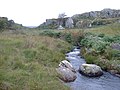 (c) David Medcalf, CC BY-SA 2.0Trittsteine über den Carrog
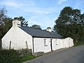 (c) Eric Jones, CC BY-SA 2.0Bod Hyfryd Cottage
 (c) Gordon Hatton, CC BY-SA 2.0Ruine eines Schieferwerkes
 (c) Eric Jones, CC BY-SA 2.0Ortsstraße
Weblinks
Einzelnachweise
- ↑ Dolbenmaen. UK Census Data, 13. Dezember 2022, abgerufen am 11. August 2025 (englisch).
Auf dieser Seite verwendete Medien

United Kingdom adm location map.svg
(c) Karte: NordNordWest, Lizenz: Creative Commons by-sa-3.0 de
Positionskarte des Vereinigten Königreichs
(c) Karte: NordNordWest, Lizenz: Creative Commons by-sa-3.0 de
Positionskarte des Vereinigten Königreichs

Two Contrasting Cottages at Dolbenmaen - geograph.org.uk - 257769.jpg
(c) Eric Jones, CC BY-SA 2.0
Two Contrasting Cottages at Dolbenmaen
(c) Eric Jones, CC BY-SA 2.0
Two Contrasting Cottages at Dolbenmaen

Bod Hyfryd - Traditional Welsh Cottage - geograph.org.uk - 257770.jpg
(c) Eric Jones, CC BY-SA 2.0
Bod Hyfryd - Traditional Welsh Cottage
(c) Eric Jones, CC BY-SA 2.0
Bod Hyfryd - Traditional Welsh Cottage

Stepping stones..... - geograph.org.uk - 234082.jpg
(c) David Medcalf, CC BY-SA 2.0
Stepping stones..... On the path to Cae Amos. The stream is not named on the OS maps, but is known locally as the Carrog. It flows down to join the Afon Dwyfor in Cwm Pennant.
(c) David Medcalf, CC BY-SA 2.0
Stepping stones..... On the path to Cae Amos. The stream is not named on the OS maps, but is known locally as the Carrog. It flows down to join the Afon Dwyfor in Cwm Pennant.

Eglwys Blwyf Dolbenmaen Parish Church - geograph.org.uk - 257782.jpg
(c) Eric Jones, CC BY-SA 2.0
Eglwys Blwyf Dolbenmaen Parish Church The church is dedicated to the BVM. The parish includes two other churches, St Michael's at Llanfihangel-y-pennant and St Beuno's at Penmorfa.
(c) Eric Jones, CC BY-SA 2.0
Eglwys Blwyf Dolbenmaen Parish Church The church is dedicated to the BVM. The parish includes two other churches, St Michael's at Llanfihangel-y-pennant and St Beuno's at Penmorfa.

Old Slate Works near Dolbenmaen - geograph.org.uk - 123596.jpg
(c) Gordon Hatton, CC BY-SA 2.0
Old Slate Works near Dolbenmaen. A relic of the old slate industry which brought prosperity to this corner of North wales in the 19th century.
(c) Gordon Hatton, CC BY-SA 2.0
Old Slate Works near Dolbenmaen. A relic of the old slate industry which brought prosperity to this corner of North wales in the 19th century.