Distrikt Huambo (Caylloma)
| Distrikt Huambo | |
|---|---|
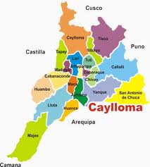
 Der Distrikt Huambo (hellbeige markiert) liegt im Westen der Provinz Caylloma | |
| Basisdaten | |
| Staat | Peru |
| Region | Arequipa |
| Provinz | Caylloma |
| Sitz | Huambo |
| Fläche | 716 km² |
| Einwohner | 670 (2017) |
| Dichte | 0,9 Einwohner pro km² |
| Gründung | 4. November 1889 |
| ISO 3166-2 | PE-ARE |
| Politik | |
| Alcalde Distrital | Felipe Getulio Huaira Soto (2019–2022) |
| Partei | Arequipa Renace |
 | |
Der Distrikt Huambo liegt in der Provinz Caylloma in der Region Arequipa in Südwest-Peru. Der Distrikt wurde am 4. November 1889 gegründet. Er hat eine Fläche von 716 km². Beim Zensus 2017 wurden 670 Einwohner gezählt.[1] Im Jahr 1993 lag die Einwohnerzahl bei 1488, im Jahr 2007 bei 895.[1] Die Distriktverwaltung befindet sich in der 3332 m hoch gelegenen Ortschaft Huambo mit 454 Einwohnern (Stand 2017). Huambo liegt 55 km westlich der Provinzhauptstadt Chivay.
Das Huambo-Vulkanfeld befindet sich zentral im Distrikt.
Geographische Lage
Der Distrikt Huambo liegt in der Cordillera Volcánica im Westen der Provinz Caylloma. Der Distrikt liegt am linken Flussufer des nach Südwesten fließenden Río Colca.
Der Distrikt Huambo grenzt im Nordosten an den Distrikt Cabanaconde, im Südosten an den Distrikt Lluta, im Südwesten an den Distrikt Huancarqui (Provinz Castilla) sowie im Nordwesten an die Distrikte Uñón, Ayo und Choco (alle drei in der Provinz Castilla).
Einzelnachweise
- ↑ a b PERU: Region Arequipa – Provinzen und Bezirke. www.citypopulation.de, abgerufen am 8. Mai 2020.
Weblinks
Auf dieser Seite verwendete Medien
The dark-brown area just north of the elongated black lake at the center of this NASA Landsat image is a lava flow from the northern segment of the Huambo volcanic field, Peru. The flows were erupted from the Cerro Keyocc cinder cone about 2650 years ago. The southern part of the volcanic field, the dark-brown area at the SW part of this image, contains several cinder cones and associated lava flows, some of which are inferred to be of early to late-Holocene age. The large glacier-covered massif to the east is the Sabancaya volcanic complex.

