Disappointment Island
| Disappointment Island | ||
|---|---|---|
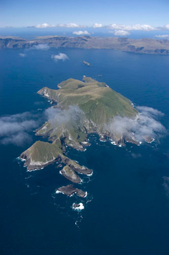
 Disappointment Island in der Mitte links im Bild zu finden | ||
| Gewässer | Südpazifik | |
| Inselgruppe | Auckland Islands | |
| Geographische Lage | 50° 36′ 15″ S, 165° 58′ 29″ O | |
| ||
| Länge | 3,5 km | |
| Breite | 1,7 km | |
| Fläche | 3 km² | |
| Höchste Erhebung | 315 m | |
| Einwohner | unbewohnt | |
 | ||
Disappointment Island (deutsch etwa „Insel der Enttäuschung“) ist die viertgrößte Insel der zu Neuseeland gehörenden Auckland Islands im südlichen Pazifischen Ozean.
Geographie
Disappointment Island liegt etwa 460 km südlich der Südinsel Neuseelands und rund 6 km westlich von Auckland Island, von dieser getrennt durch eine 73 Meter tiefe Passage. Sie ist 3,5 km lang, bis zu 1,7 km breit und weist eine Fläche von etwa 3 km² auf. Die stark zerklüftete und hügelige Insel ist geprägt von steilen Küstenkliffs aus Basalt und erreicht eine Höhe von 315 m über dem Meer.
Geschichte

Wie die gesamte Inselgruppe wurde Disappointment Island am 18. August 1806 von Europäern entdeckt. Am 14. Mai 1866 zerschellte die General Grant an der Westküste von Auckland Island. 15 Überlebende schafften es auf Disappointment Island und wurden erst 18 Monate später gerettet.[1] Am 7. März 1907 lief die Viermastbark Dundonald an der Westküste der Insel auf Grund und sank. Die 16 Überlebenden mussten sieben Monate bis zur Rettung auf der Insel ausharren.[2]
Flora und Fauna
Die Insel ist – neben Adams Island – eines der beiden letzten Rückzugsgebiete der bereits für ausgestorben gehaltenen und erst 1966 wiederentdeckten, endemischen Aucklandralle (Lewinia muelleri).[3] Bekannt ist die Insel auch für zahlreiche Seevögel, unter anderen lebt auf ihr mit etwa 72.000 Paaren nahezu die gesamte Weltpopulation von Thalassarche cauta steadi, einer Unterart des Weißkappenalbatros (Thalassarche cauta) – Stand 2008.[4]
Literatur
- Ronald Jones: Gold Sunken – General Grant. In: Alexander Hare McLintock (Hrsg.): An Encyclopaedia of New Zealand. Wellington 1966 (englisch, Online und 2 weitere Seiten [abgerufen am 15. Dezember 2015]).
Weblinks
Einzelnachweise
- ↑ Jones: Gold Sunken – General Grant. In: An Encyclopaedia of New Zealand. 1966.
- ↑ Wrecked on the Auckland Islands in 1907 (englisch)
- ↑ Factsheet Lewinia muelleri auf BirdLife International
- ↑ Factsheet Thalassarche cauta auf BirdLife International
Auf dieser Seite verwendete Medien
Photo of a grave on Auckland Islands

Autor/Urheber: Rosso Robot, Lizenz: CC BY-SA 3.0
Positionskarte von Neuseeland
Quadratische Plattkarte, N-S-Streckung 150 %, Geographische Begrenzung der Karte:
- N: −43° S
- S: −56° S
- W: 158.4° O
- O: −174.6° W
STS089-743-5 Auckland Islands, New Zealand January 1998.
The barren, mountainous landscape of the Auckland Islands can be seen in this spectacular west-looking view. The uninhabited Auckland Islands are 290 miles (461 km) south of South Island, New Zealand in the southern Pacific Ocean. The total area of the islands is 234 square miles (377 square km). Auckland Island is the largest of the group and is 27 miles (44 km) long and 15 miles (24 km) wide. Mountains on the island rise up to over 2000 feet (610 meters) above sea level. The islands have several good harbors especially the one at Port Ross, which is situated at the northern tip of the island and is considered to be one of the best natural harbors in the world. The government of New Zealand maintains a depot on Auckland Island with supplies for shipwrecked sailors. During the STS-89 mission (1/29/98) there was a report of about 700 rare New Zealand seal lion pups found dead on the beaches of Dundas Island in the Auckland Island group. As of this this writing, results of autopsies conducted by biologists of the New Zealand Department of Conservation are not yet known. The animals had not been caught in nets or injured by trawlers; possible causes of death include a virus, bacteria, or a toxic algae bloom.Autor/Urheber: Jackaranga, Lizenz: CC BY-SA 3.0
Topographic map of the Auckland Islands