Darwin Mountains
| Darwin Mountains | ||
|---|---|---|
| Höchster Gipfel | Mount Ellis (2330 m) | |
| Lage | Viktorialand, Ostantarktika | |
| Teil des | Transantarktischen Gebirges | |
| ||
| Koordinaten | 79° 51′ S, 156° 15′ O | |
Die Darwin Mountains sind ein Gebirgszug zwischen dem Darwin-Gletscher und dem Hatherton-Gletscher im südlichen ostantarktischen Viktorialand.
Entdeckt wurden sie von Teilnehmern der Discovery-Expedition (1901–1904) unter der Leitung des britischen Polarforschers Robert Falcon Scott, der sie nach Leonard Darwin (1850–1943) benannte, Ehrenpräsident der Royal Geographical Society.
Weblinks
- Darwin Mountains auf geographic.org (englisch)
- Darwin Mountains. In: Geographic Names Information System. United States Geological Survey, United States Department of the Interior, archiviert vom (englisch).
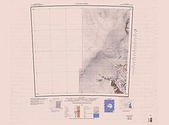 Westteil im Südosten der Karte
 Ostteil im Südwesten der Karte
Auf dieser Seite verwendete Medien

C79197s1 Ant.Map Carlyon Glacier.jpg
Map of Antarctica by the United States Antarctic Resource Center of the US Geological Society.
Map of Antarctica by the United States Antarctic Resource Center of the US Geological Society.

Antarctica relief location map.jpg
Autor/Urheber: Alexrk2, Lizenz: CC BY-SA 3.0
Physische Positionskarte Antarktis, Mittabstandstreue Azimutalprojektion
Autor/Urheber: Alexrk2, Lizenz: CC BY-SA 3.0
Physische Positionskarte Antarktis, Mittabstandstreue Azimutalprojektion

C79204s1 Ant.Map Turnstile Ridge.jpg
1:250,000-scale topographic reconnaissance map of the Turnstile Ridge area from 150°-156'E to 79°-80°S in Antarctica. Mapped, edited and published by the U.S. Geological Survey in cooperation with the National Science Foundation.
1:250,000-scale topographic reconnaissance map of the Turnstile Ridge area from 150°-156'E to 79°-80°S in Antarctica. Mapped, edited and published by the U.S. Geological Survey in cooperation with the National Science Foundation.