Coll Airport
| Coll Airport | ||
|---|---|---|
(c) Gordon Brown, CC BY-SA 2.0 | ||
| ||
| Kenndaten | ||
| ICAO-Code | EGEL | |
| IATA-Code | COL | |
| Koordinaten | 56° 36′ 7″ N, 6° 37′ 4″ W | |
| Höhe über MSL | 6 m (20 ft) | |
| Verkehrsanbindung | ||
| Entfernung vom Stadtzentrum | 9,3 km südwestlich von Arinagour | |
| Basisdaten | ||
| Betreiber | Argyll and Bute Council | |
| Start- und Landebahn | ||
| 02/20 | 500 m × 18 m Asphalt | |
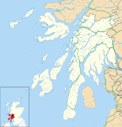
Der Coll Airport (schottisch-gälisch Port-adhair Cholla, IATA-Code: COL, ICAO-Code: EGEL) befindet sich auf der Hebrideninsel Coll in der Council Area Argyll and Bute vor der Westküste Schottlands. Betreiber und Besitzer ist das Argyll and Bute Council. Highland Airways, die ursprünglich die Route nach Oban betrieben haben, ging in Konkurs im Jahr 2010, aber es fand sich ein neuer Betreiber, Hebridean Air Services betreibt nun die Strecke unter einer PSO (Public service obligation; deut.: Gemeinwirtschaftliche Verpflichtung) mit Flügen nach Oban und Tiree mit Britten-Norman Islander Flugzeugen.
Weblinks
Auf dieser Seite verwendete Medien
(c) Gordon Brown, CC BY-SA 2.0
New terminal building at Coll Aerodrome
Contains Ordnance Survey data © Crown copyright and database right, CC BY-SA 3.0
Blank map of Argyll and Bute, UK with the following information shown:
- Administrative borders
- Coastline, lakes and rivers
- Roads and railways
- Urban areas
Equirectangular map projection on WGS 84 datum, with N/S stretched 175%
Geographic limits:
- West: 7.2W
- East: 4.5W
- North: 56.8N
- South: 55.2N


