Chatham Island
| Chatham Island | ||
|---|---|---|
 | ||
| Gewässer | Pazifischer Ozean | |
| Inselgruppe | Chatham-Inseln | |
| Geographische Lage | 43° 54′ S, 176° 32′ W | |
| ||
| Fläche | 899 km² | |
| Höchste Erhebung | Maungatere Hill 294 m | |
| Einwohner | 564 (2006) <1 Einw./km² | |
| Hauptort | Waitangi | |
 | ||
Chatham Island (Moriori: Rēkohu; Māori: Wharekauri) ist die größte Insel im Archipel der zu Neuseeland gehörenden Chatham-Inseln im südwestlichen Pazifik.
Geographie
Die T-förmige, 899 km² große Insel ist geprägt von zwei großen Buchten, der Petre Bay im Westen mit dem Hauptort Waitangi und der über 35 km langen Hanson Bay im Osten. Dazwischen befindet sich die 179 km² große Te Whanga-Lagune, die nur durch Landbrücken von der See getrennt ist. Der Süden der Insel wird von einem Hochplateau eingenommen und erreicht im Maungatere Hill eine Höhe von 294 m über dem Meer. Weiterhin gibt es Torflandschaften und lange Sandstrände. Auf einer in die Lagune ragenden Halbinsel befindet sich der Flughafen Tuuta (IATA: CHT, ICAO: NZCI).
Geschichte
Die Ureinwohner der Chatham Islands (Rēkohu) sind die Moriori. Nach ihren Überlieferungen stammten sie von Rongomaiwhenua aus Ost-Polynesien ab. Das Datum der Besiedlung ist unklar, Schätzungen reichen vom 13. bis zum 16. Jahrhundert n. Chr.[1] Es gab neun Stämme, die auf Chatham und Pitt Island siedelten.[2] Die Bevölkerung vor dem Kontakt mit Europäern wird auf ca. 2000 geschätzt[3]. Ihre Wirtschaft beruhte vor allem auf Meeresprodukten.
1791 landete der Brite William Broughton und die Besatzung des Schiffes Chatham auf der Insel[4]. Ab 1810 ließen sich weiße Seehund- und Walfänger auf Chatham Island nieder[5]. Sie schleppten Krankheiten ein, 1828–1832 kam es zu Grippe- und Masern-Epidemien[6].
Die Moriori wurden 1835 von ca. 900 Mitgliedern der Maori Stämme Ngāti Tama und Ngāti Mutunga von der Nordinsel Neuseelands verschleppt, versklavt und weitgehend ausgerottet[7]. Sie mieteten dazu die britische Brigg Rodney an[8]. Die britische Kolonialmacht griff nicht ein.
1842 annektierte Neuseeland die Inseln.[9]
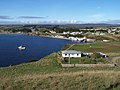 Hauptort Waitangi
Einzelnachweise
- ↑ André Brett, ‘The miserable remnant of this ill-used people’: colonial genocide and the Moriori of New Zealand's Chatham Islands. Journal of Genocide Research 17/2, 2015, 135. DOI:10.1080/14623528.2015.1027073
- ↑ André Brett, ‘The miserable remnant of this ill-used people’: colonial genocide and the Moriori of New Zealand's Chatham Islands. Journal of Genocide Research 17/2, 2015, 136. DOI:10.1080/14623528.2015.1027073
- ↑ André Brett, ‘The miserable remnant of this ill-used people’: colonial genocide and the Moriori of New Zealand's Chatham Islands. Journal of Genocide Research 17/2, 2015, 137. DOI:10.1080/14623528.2015.1027073
- ↑ André Brett, ‘The miserable remnant of this ill-used people’: colonial genocide and the Moriori of New Zealand's Chatham Islands. Journal of Genocide Research 17/2, 2015, 136. DOI:10.1080/14623528.2015.1027073
- ↑ André Brett, ‘The miserable remnant of this ill-used people’: colonial genocide and the Moriori of New Zealand's Chatham Islands. Journal of Genocide Research 17/2, 2015, 136. DOI:10.1080/14623528.2015.1027073
- ↑ André Brett, ‘The miserable remnant of this ill-used people’: colonial genocide and the Moriori of New Zealand's Chatham Islands. Journal of Genocide Research 17/2, 2015, 137. DOI:10.1080/14623528.2015.1027073
- ↑ André Brett, ‘The miserable remnant of this ill-used people’: colonial genocide and the Moriori of New Zealand's Chatham Islands. Journal of Genocide Research 17/2, 2015, 135. DOI:10.1080/14623528.2015.1027073
- ↑ André Brett, ‘The miserable remnant of this ill-used people’: colonial genocide and the Moriori of New Zealand's Chatham Islands. Journal of Genocide Research 17/2, 2015, 138. DOI:10.1080/14623528.2015.1027073
- ↑ André Brett, ‘The miserable remnant of this ill-used people’: colonial genocide and the Moriori of New Zealand's Chatham Islands. Journal of Genocide Research 17/2, 2015, 136. DOI:10.1080/14623528.2015.1027073
Weblinks
- Chatham Islands - Natural Heritage. Kiwi Favourites, abgerufen am 5. Januar 2016 (englisch, Blog mit verschiedenen Artikeln zum Thema).
Auf dieser Seite verwendete Medien
NASA-Astronautenbild der Chatham-Inseln, Neuseeland, im Pazifischen Ozean

Autor/Urheber: Rosso Robot, Lizenz: CC BY-SA 3.0
Positionskarte von Neuseeland
Quadratische Plattkarte, N-S-Streckung 150 %, Geographische Begrenzung der Karte:
- N: −43° S
- S: −56° S
- W: 158.4° O
- O: −174.6° W

Autor/Urheber: Vk2cz, Lizenz: CC BY 3.0
Town of Waitangi on Chatham Island. Taken from just north of town center, or coords -43.946094,-176.562055
Autor/Urheber: modified by Telim tor, Lizenz: CC BY-SA 2.5
Topographische Karte der Chatham-Insel, Hauptinsel der Chatham-Inseln, Neuseeland