Chandannagar
| Chandannagar | ||
|---|---|---|
| Staat: | ||
| Bundesstaat: | Westbengalen | |
| Distrikt: | Hugli | |
| Subdistrikt: | Chandannagar | |
| Lage: | 22° 51′ N, 88° 21′ O | |
| Höhe: | 14 m | |
| Einwohner: | 166.949 (2011)[1] | |
| Website: | http://chandernagoremunicipalcorporation.in | |
 | ||
Chandannagar (bengalisch:চন্দননগর, Candannagar; früher franz. Chandernagor) ist eine Stadt im Distrikt Hugli im indischen Bundesstaat Westbengalen. Die Stadt liegt rund 40 Kilometer nördlich von Kolkata und hat etwa 167.000 Einwohner (Volkszählung 2011). Chandannagar gehört zur Metropolregion Kolkata.
Geschichte

Chandannagar wurde 1673 gegründet und war mit Unterbrechungen durch britische Besatzung bis zur Mitte des 20. Jahrhunderts eine französische Kolonie.[2] 1949 kam es zur Volksabstimmung über den Verbleib von Französisch-Indien als freie Städte in der Französischen Union oder den Anschluss an Indien, wobei sich nur Chandannagar für den Anschluss entschied. Am 2. Oktober 1954 wurde es durch den Chandernagore Merger Act in Westbengalen integriert.[3] Die restlichen Städte folgten 1956 (staatsrechtlich 1962) und bilden heute das Unionsterritorium Puducherry.
Söhne der Stadt
- Pashupati Chatterjee (1906–1990), Filmregisseur und Journalist
- Ian G. Kidd (1922–2011), britischer Altphilologe und Philosophiehistoriker
Weblinks
Einzelnachweise
- ↑ Census of India 2011: Provisional Population Totals. Cities having population 1 lakh and above. (PDF; 154 kB)
- ↑ Percival Spear: A History of India, Bd. 2: From the sixteenth century to the twentieth century. Penguin, Harmondsworth, 5. Aufl. 1973, S. 68.
- ↑ (PDF, S. 5)
Auf dieser Seite verwendete Medien
Autor/Urheber: AshwiniKalantri, Lizenz: CC BY-SA 3.0
Location map of India with Indian claimed territories in grey. Equirectangular projection. Strechted by 106.0%. Geographic limits of the map: * N: 37.5° N * S: 5.0° N * W: 67.0° E * E: 99.0° E Made with Natural Earth. Free vector and raster map data @ naturalearthdata.com.
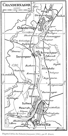
Map of Chandernagor (today Chandernaggar), one of the five settlements of French India, in relation to Calcutta, 1900.
Autor/Urheber: Aryan paswan, Lizenz: CC BY-SA 3.0
Dieses Bild zeigt das ASI-Denkmal mit der Nummer


