California State Route 79
 | |
|---|---|
| Karte | |
 | |
| Basisdaten | |
| Gesamtlänge: | 106,7 mi/171,8 km |
| Anfangspunkt: | |
| Endpunkt: | |
| Countys: | San Diego County Riverside County |
Die California State Route 79, abgekürzt CA 79, ist eine State Route im US-Bundesstaat Kalifornien von knapp 172 Kilometern Länge. Die State Route beginnt an der Interstate 10 in Riverside und endet beim San Diego County an der Interstate 8.
Diese State Route ist Teil des California Freeway and Express System und ist bestellbar für das State Scenic Highway System.
Verlauf
Die Route 79 beginnt in der Nähe von Beaumont an der Interstate 10. In der Nähe von Julian passiert die CA 79 die California State Route 78. Der nächste größere Ort durch den die State Route führt ist Murrieta und Temecula. Die CA 79 führt danach über eine Hügelkette (Lambs Canyon) zu San Jacinto und Hemet. Dann, endet sie in Descanso.

California State Route 79

California State Route 79 und Cuyamaca-See
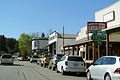
California State Route 78 und 79 in Julian
Siehe auch
Weblinks
- AARoads: California 79 (englisch)
- California Highways: State Route 79 (englisch)
Auf dieser Seite verwendete Medien

Vector image of a 24 in by 25 in (600 mm by 635 mm) California State Route shield. Colors are from [1] (Pantone Green 342), converted to RGB by [2]. The outside border has a width of 1 (1/16 in) and a color of black so it shows up; in reality, signs have no outside border.
Vector image of a 24 in by 25 in (600 mm by 635 mm) California State Route shield. Colors are from [1] (Pantone Green 342), converted to RGB by [2]. The outside border has a width of 1 (1/16 in) and a color of black so it shows up; in reality, signs have no outside border.

Vector image of a 24 in by 25 in (600 mm by 635 mm) California State Route shield. Colors are from [1] (Pantone Green 342), converted to RGB by [2]. The outside border has a width of 1 (1/16 in) and a color of black so it shows up; in reality, signs have no outside border.

Shield for California State Route 74, located in Southern California.
Vector image of a 24 in by 25 in (600 mm by 635 mm) California State Route shield.

Autobahnkreuz (Icon) in blau.

Vector image of a 24 in by 25 in (600 mm by 635 mm) California State Route shield. Colors are from [1] (Pantone Green 342), converted to RGB by [2]. The outside border has a width of 1 (1/16 in) and a color of black so it shows up; in reality, signs have no outside border.


Autor/Urheber: Adbar, Lizenz: CC BY-SA 3.0
CA 79 looking north with lake Cuyamaca on the right.

This is a map of State Route 79 in California.


Autor/Urheber: Adbar, Lizenz: CC BY-SA 3.0
Steven Rucker Memorial Highway sign, looking north, near Lake Cuyamaca (south of Julian).


Autor/Urheber: Adbar, Lizenz: CC BY-SA 3.0
California State Route 78 and 79 in Julian.