Burrelton
| Burrelton schottisch-gälisch Both Bhùirnich | |||
|---|---|---|---|
 (c) James Allan, CC BY-SA 2.0 | |||
| Koordinaten | 56° 31′ N, 3° 18′ W | ||
| |||
| Traditionelle Grafschaft | Perthshire | ||
| Einwohner | 671 Zensus 2011 | ||
| Verwaltung | |||
| Post town | BLAIRGOWRIE | ||
| Postleitzahlenabschnitt | PH13 | ||
| Vorwahl | 01828 | ||
| Landesteil | Scotland | ||
| Council area | Perth and Kinross | ||
| Britisches Parlament | Perth and North Perthshire | ||
| Schottisches Parlament | Perthshire North | ||
Burrelton ist eine Ortschaft in der schottischen Council Area Perth and Kinross und der traditionellen schottischen Grafschaft Perthshire. Sie ist etwa 16 km nordöstlich von Perth und etwa 19 km westnordwestlich von Dundee gelegen. Burrelton grenzt direkt an den Nachbarort Woodside an.[1] Im Jahre 2011 verzeichnete Burrelton 671 Einwohner, was einer Zunahme von der Zahl von 382 im Jahre 1961 bedeutete.[2][3]
Burrelton liegt zwischen den Sidlaw Hills im Südosten und dem Fluss Tay im Norden. Es ist über die A94, die von Perth nach Forfar führt, an das Fernstraßennetz angeschlossen. Die nächstgelegenen Städte entlang der Straße sind Scone im Südwesten und Coupar Angus im Nordosten. Der nächstgelegene Flughafen ist der etwa neun Kilometer in südwestlicher Richtung gelegene Perth Airport. Einst war Burrelton an das Schienennetz angeschlossen[4], der Bahnhof wurde jedoch zwischenzeitlich aufgegeben.
 (c) Ben Brooksbank, CC BY-SA 2.0
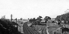
Ehemaliger Bahnhof von Burrelton 1974
 (c) Ben Brooksbank, CC BY-SA 2.0
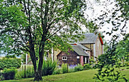
Bahnhofsgebäude 1997
Einzelnachweise
- ↑ Burrelton. Perth and Kinross. In: David Munro, Bruce Gittings: Scotland. An Encyclopedia of Places & Landscapes. Collins u. a., Glasgow 2006, ISBN 0-00-472466-6.
- ↑ Statistische Daten
- ↑ Zensus 2011
- ↑ Burrelton. In: Francis H. Groome: Ordnance Gazetteer of Scotland: A Survey of Scottish Topography, Statistical, Biographical and Historical. Band 1: (A – Coru). Thomas C. Jack, Grange Publishing Works, Edinburgh u. a. 1882, S. 204.
Weblinks
- Eintrag zu Burrelton, Village (19th Century) (1812) in Canmore, der Datenbank von Historic Environment Scotland (englisch).
Auf dieser Seite verwendete Medien
_-_geograph.org.uk_-_1951329.jpg)
(c) Ben Brooksbank, CC BY-SA 2.0
Burrelton Station (remains).
View westward, towards Stanley Junction and Perth; ex-Caledonian, Perth - Stanley Junction - Forfar - Aberdeen (Strathmore) main line. Named 'Woodside & Burrelton' until 9/27, this station was closed on 11/6/56. Passenger services on the main line had ceased from 4/9/67 and by the date (9/74) of this photograph the line had been singled; local goods trains ran from Stanley Junction as far as Forfar until 5/6/82.

(c) Ben Brooksbank, CC BY-SA 2.0
Former Burrelton station house, 1997.
View southward: ex-Caledonian Railway Perth - Forfar - Bridge of Dun - Aberdeen main line, which in this scene had probably been on the far side of the house. The station ('Woodside & Burrelton' until 1/9/27) was closed 11/6/56 and the whole route abandoned from 4/9/67.

(c) Eric Gaba, NordNordWest, CC BY-SA 3.0
Positionskarte von Schottland, Vereinigtes Königreich