Badenoch
.png)
Badenoch (schottisch-gälisch Bàideanach, deutsch versunkenes Land) ist ein historischer schottischer Distrikt im heutigen Verwaltungsbezirk Highland.
Geographie
Badenoch umfasst etwa 1400 km² und ist von Norden nach Süden etwa 24 km und von Osten nach Westen etwa 58 km groß. Im Norden wird Badenoch von den Monadhliath Mountains begrenzt, im Osten von den Cairngorm Mountains und Braemar, im Süden von Atholl und den Grampian Mountains, im Westen vom Lochaber. Die historische Hauptstadt Badenochs ist Kingussie. Mit Ausnahme des Speytals und seiner größeren Seitentäler besteht Badenoch fast vollständig aus ursprünglicher Berglandschaft, von deren Gipfeln viele eine Höhe von 1000 m erreichen. Die ausgedehnten Wälder und Heidegebiete um den Ben Alder, Drumochter, Gaick und Feshie weisen umfangreiche Rotwildbestände auf. Die größten Seen sind der Loch Laggan, Loch Insh und der Loch Ericht. Der Fluss Spey und seine unzähligen Zuflüsse versorgen Badenoch mit Wasser.
Geschichte

Im Jahre 1229 wurde Badenoch durch den neu geschaffenen Titel des Lord of Badenoch erstmals zu einem einheitlichen Herrschaftsgebiet. Der Titel wurde zunächst bis etwa 1313 vom Clan Comyn gehalten. Ab 1314 fiel Badenoch an den Earl of Moray. Ab dem 15. Jahrhundert gehörte Badenoch zum Earldom of Huntly, der auch den nachgeordneten Titel Lord of Badenoch trug.
Im 19. Jahrhundert wurde der traditionelle Distrikt Badenoch in das County Inverness-shire eingegliedert. Von 1975 bis 1996 bildete Badenoch zusammen mit der benachbarten Region Strathspey den gemeinsamen Verwaltungsdistrikt Badenoch and Strathspey. Nach einer Verwaltungsreform Ende der 1990er-Jahre gehört Badenoch nun zur Council Area Highland.
Wirtschaft
Badenoch verfügt über sehr wenig Industrie. Der Großteil der Einwohner lebt in Kingussie und einigen Dörfern entlang des Spey. Die Highland Main Line erschließt Badenoch mit Bahnhöfen in Dalwhinnie, Newtonmore, Kingussie und Aviemore.
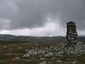 (c) Andrew Spenceley, CC BY-SA 2.0Großes Steinmännchen bei Kingussie am Rand der Monadhliath Mountains
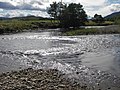 (c) Mark Thomas, CC BY-SA 2.0Der Fluss Spey
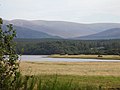 (c) Richard Webb, CC BY-SA 2.0Der Loch Insh
 (c) Ewen Rennie, CC BY-SA 2.0Der Dunachtonstone, ein Stein am Loch Insh aus der Zeit der Pikten
Literatur
- Conrad Malte-Brun, Jean-Jacques-Nicolas Huot: A system of universal geography. A description of all the parts of the world, on a new plan, according to the great natural divisions of the globe. Band 3. Samuel Walker, Boston 1834, S. 1282 (englisch, books.google.com).
- Lachlan Shaw: The history of the province of Moray. J. Gran, 1827, S. 6 ff. (books.google.com – New Edition).
- Badenoch. In: Encyclopædia Britannica. 11. Auflage. Band 3: Austria – Bisectrix. London 1910, S. 188 (englisch, Volltext [Wikisource]).
Auf dieser Seite verwendete Medien
(c) John S Ross, CC BY-SA 2.0
Tigh Dubh and peat stack Black House (Tigh Dubh), peat stack and barrow at the Highland Folk Museum Kingussie.


(c) Mark Thomas, CC BY-SA 2.0
Currents in the River Spey The river flows either side of an island. It rejoins at this point.

(c) Andrew Spenceley, CC BY-SA 2.0
Large cairn on Monadhliath This large cairn is very near the summit of the "corbett" Carn an Fhreiceadain and is visible on the skyline as you climb the hill from Kingussie. From here you get a superb view across the high rolling Monadhliath hills and (on a good day - not the day this photo was taken ! ) across the Spey to the distance Feshie Hills and Cairngorms.

(c) Richard Webb, CC BY-SA 2.0
Loch Insh. Loch on the Spey, with miles of marshland upstream towards Kingussie. Many of the outstanding features of the Cairngorm National Park are visible here. The loch and marshes, the vast forests of Glen Feshie and Inshriach, with the 1100m granite hills of the western Monadh Ruadh beyond. Loch Insh is a popular water sport site, with a popular centre at the downstream end.
Autor/Urheber: Benson85 at English Wikipedia, Lizenz: CC BY-SA 3.0
Map showing roughly the district of Badenoch in Scotland.