Toni-Hongo village after the 1933 Showa Sanriku tsunami, before the 2011 Tohoku tsunami, and after the 2011 Tohoku tsunami

Autor/Urheber:
Anawat Suppasri, Nobuo Shuto, Fumihiko Imamura, Shunichi Koshimura, Erick Mas, Ahmet Cevdet Yalciner: "Lessons Learned from the 2011 Great East Japan Tsunami: Performance of Tsunami Countermeasures, Coastal Buildings, and Tsunami Evacuation in Japan", Pure and Applied Geophysics, 170, 6-8, (2013), pp. 993–1018, DOI: https://doi.org/10.1007/s00024-012-0511-7, online published on 7 July 2012, here: p. 1014, Figure 29 ("Toni-Hongo village after the 1933 Showa Sanriku tsunami, before the 2011 Tohoku tsunami, and after the 2011 Tohoku tsunami"), License: Creative Commons Attribution 2.0 Generic (CC BY 2.0). URL of the image file: https://media.springernature.com/original/springer-static/image/art%3A10.1007%2Fs00024-012-0511-7/MediaObjects/24_2012_511_Fig29_HTML.jpg.
Shortlink:
Quelle:
Größe:
746 x 180 Pixel (38196 Bytes)
Beschreibung:
Source: Anawat Suppasri, Nobuo Shuto, Fumihiko Imamura, Shunichi Koshimura, Erick Mas, Ahmet Cevdet Yalciner: "Lessons Learned from the 2011 Great East Japan Tsunami: Performance of Tsunami Countermeasures, Coastal Buildings, and Tsunami Evacuation in Japan", Pure and Applied Geophysics, 170, 6-8, (2013), pp. 993–1018, DOI: https://doi.org/10.1007/s00024-012-0511-7, online published on 7 July 2012, here: p. 1014, Figure 29 ("Toni-Hongo village after the 1933 Showa Sanriku tsunami, before the 2011 Tohoku tsunami, and after the 2011 Tohoku tsunami"), License: Creative Commons Attribution 2.0 Generic (CC BY 2.0). URL of the image file: https://media.springernature.com/original/springer-static/image/art%3A10.1007%2Fs00024-012-0511-7/MediaObjects/24_2012_511_Fig29_HTML.jpg.
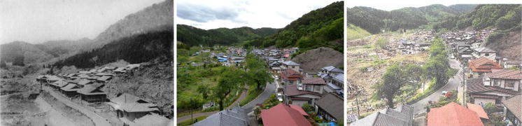
Caption as given in the above cited source: "Figure 29 - Toni-Hongo village after the 1933 Showa Sanriku tsunami, before the 2011 Tohoku tsunami, and after the 2011 Tohoku tsunami"
Context as given in the above cited source: "The Toni-Hongo village was struck by the 1896 tsunami (with a tsunami height of 14.5 m and 224 houses destroyed) and the 1933 tsunami (with a tsunami height of 9.3 m and 101 houses destroyed) (Meiji University, 2011). After the 1933 tsunami, the village was rebuilt on high land at an elevation of 20 m (MSL), as shown in Fig. 29, left. The village survived the 1960 Chilean tsunami, which was ~5 m high. After this event, many houses were built in the lowland areas to accommodate the increasing population, as shown in a picture from 2009 (Fig. 29, center) and a satellite image from 2010 (Fig. 30, left). The 2011 tsunami destroyed the lowland houses but not the highland houses (Figs. 29, right, 30, right)."
Kommentar zur Lizenz:
Diese Datei ist unter der Creative-Commons-Lizenz „Namensnennung 2.0 generisch“ (US-amerikanisch) lizenziert.
Namensnennung: Anawat Suppasri, Nobuo Shuto, Fumihiko Imamura, Shunichi Koshimura, Erick Mas, Ahmet Cevdet Yalciner
- Dieses Werk darf von dir
- verbreitet werden – vervielfältigt, verbreitet und öffentlich zugänglich gemacht werden
- neu zusammengestellt werden – abgewandelt und bearbeitet werden
- Zu den folgenden Bedingungen:
- Namensnennung – Du musst angemessene Urheber- und Rechteangaben machen, einen Link zur Lizenz beifügen und angeben, ob Änderungen vorgenommen wurden. Diese Angaben dürfen in jeder angemessenen Art und Weise gemacht werden, allerdings nicht so, dass der Eindruck entsteht, der Lizenzgeber unterstütze gerade dich oder deine Nutzung besonders.
Lizenz:
Credit:
Anawat Suppasri, Nobuo Shuto, Fumihiko Imamura, Shunichi Koshimura, Erick Mas, Ahmet Cevdet Yalciner: "Lessons Learned from the 2011 Great East Japan Tsunami: Performance of Tsunami Countermeasures, Coastal Buildings, and Tsunami Evacuation in Japan", Pure and Applied Geophysics, 170, 6-8, (2013), pp. 993–1018, DOI: https://doi.org/10.1007/s00024-012-0511-7, online published on 7 July 2012, here: p. 1014, Figure 29 ("Toni-Hongo village after the 1933 Showa Sanriku tsunami, before the 2011 Tohoku tsunami, and after the 2011 Tohoku tsunami"), License: Creative Commons Attribution 2.0 Generic (CC BY 2.0). URL of the image file: https://media.springernature.com/original/springer-static/image/art%3A10.1007%2Fs00024-012-0511-7/MediaObjects/24_2012_511_Fig29_HTML.jpg.
Bild teilen:


Relevante Bilder


(c) Anawat Suppasri, Nobuo Shuto, Fumihiko Imamura, Shunichi Koshimura, Erick Mas, Ahmet Cevdet Yalciner, CC BY 2.0

(c) Anawat Suppasri, Nobuo Shuto, Fumihiko Imamura, Shunichi Koshimura, Erick Mas, Ahmet Cevdet Yalciner, CC BY 2.0


(c) Anawat Suppasri, Nobuo Shuto, Fumihiko Imamura, Shunichi Koshimura, Erick Mas, Ahmet Cevdet Yalciner, CC BY 2.0


(c) ひでわく, CC BY 2.1 jp


Relevante Artikel
KamaishiKamaishi ist eine Stadt in der Präfektur Iwate auf Honshū, der Hauptinsel von Japan. .. weiterlesen