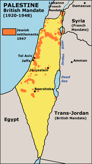
Map of Jewish settlements in Palestine in 1947
Autor/Urheber:
JamesDay in der Wikipedia auf Englisch
Shortlink:
Quelle:
Größe:
312 x 556 Pixel (60723 Bytes)
Beschreibung:
Map of Jewish settlements in Palestine in 1947.
Kommentar zur Lizenz:
GFDL derivative work created by the uploader based on a portion of the public domain work http://www.lib.utexas.edu/maps/historical/israel_hist_1973.jpg . At http://www.lib.utexas.edu/maps/faq.html that site states that "Most of the maps scanned by the General Libraries and served from this web site are in the public domain. No permissions are needed to copy them. You may download them and use them as you wish. A few maps are copyrighted, and are clearly marked as such". There is no such mark with this map, so it is presumed to have been in the public domain before the derivative work was created. The uploader hereby releases the derivative work under the GFDL.
Lizenz:
Credit:
Übertragen aus en.wikipedia nach Commons mithilfe des CommonsHelper.
Bild teilen:


Relevante Bilder
%2c_administrative_divisions_-_de_-_colored.svg)
.svg)
_(Europe_centered).svg)


.jpg)


.jpg)

Relevante Artikel
IsraelIsrael, amtlich Staat Israel, ist ein Staat in Vorderasien an der Ostküste des Mittelmeers. Israel ist der einzige Staat der Erde mit mehrheitlich jüdischer Bevölkerung und versteht sich als Nationalstaat des jüdischen Volkes. Israel gehört geographisch zum Maschrek und grenzt an den Libanon, Syrien, Jordanien, Ägypten sowie an den Gazastreifen und das Westjordanland. Die Hauptstadt und bevölkerungsreichste Stadt Israels ist Jerusalem; jedoch erkennen die Vereinten Nationen und die Mehrheit ihrer Mitgliedstaaten Jerusalem nicht als israelische Hauptstadt an. Der größte Ballungsraum ist Gusch Dan um die am Mittelmeer gelegene Metropole Tel Aviv-Jaffa. .. weiterlesen