Breakup of Yugoslavia
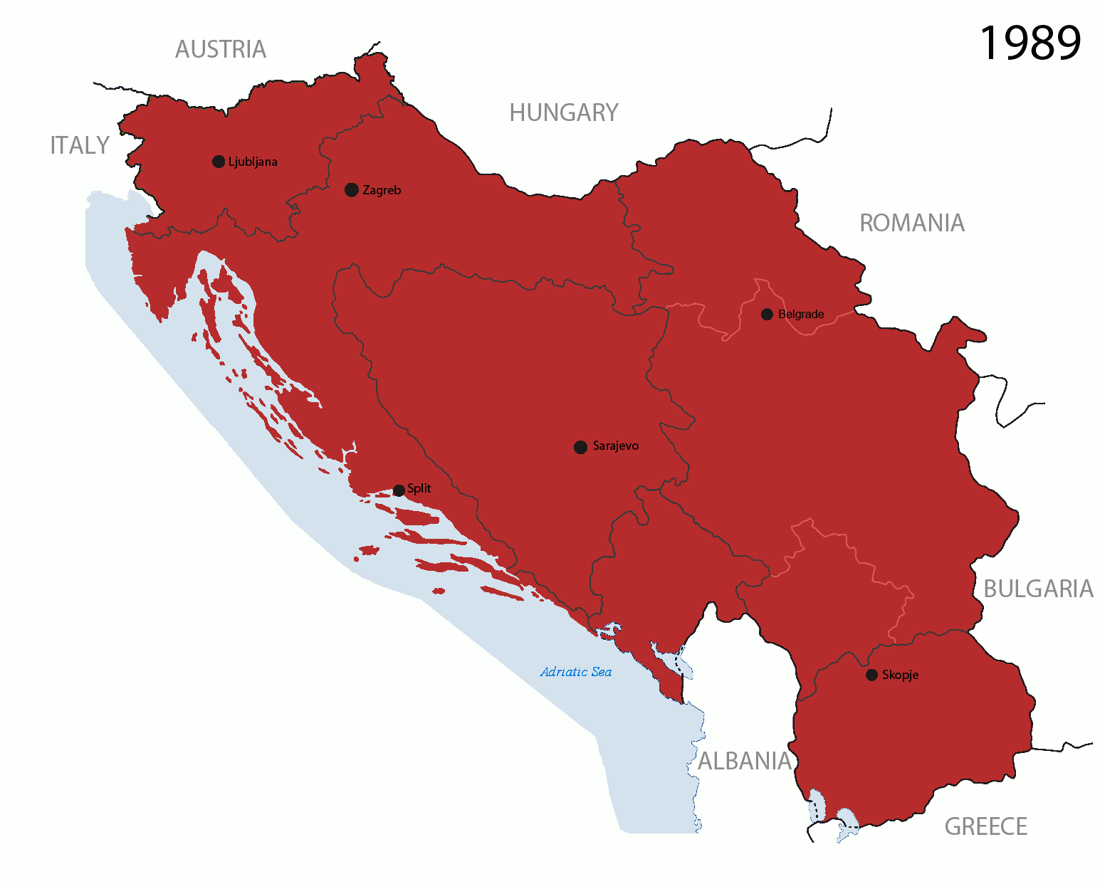
This is an animated GIF that shows the stages of the breakup of the SFR Yugoslavia in the 90's and 2000's. The map based off Morwen's map of the divisions of the SFRY, Which is licensed by the GFDL. The source for the dates of independence is the CIA World Factbook. These maps do not now show the Inter-Entity Boundary Line (IEBL) and/or the entities that are separated by it. The IEBL has been drawn based on this CIA map; the Brčko District has been drawn based on Image:BH municipality location.gif, by user:Ante Perkovic. I might add them in the future.
Since the original map was GFDL, this image is as well.
A map depicting Kosovo's final status is ready once it takes effect.
Changelog for versions 2/3:
Here are some changes in this new build of the map:
- The Kosovo boundary has been given a shade of red instead of the previous UN blue since they are a province of Serbia under UNIMIK control.
- Montenegro's color has been changed to a golden shade close to what's on the flag.
- The IEBL and the Brčko District has been redrawn because I deleted the original map; the color for the Republika Srpska is lighter.
- The dates are at the top left hand corner of the map instead of the bottom.
- I have taken a new approach as to the boundaries. Each part of Yugoslavia now shows the boundary on the maps starting the year they broke away. I feel this change helps readers understand the breakup better.
- The SFRY and the FRY are in different shades since the FRY was never accepted as the successor to the former by the UN.
- The colors for the entities of BiH have been removed as to not confuse people into thinking that they are independent states. What remains is the IEBL with both entities in green.
- The Kosovo boundary is finally in hash marks!
- The Brčko District has been removed. The sale is too small to show accurately.
Changelog for version 4:
- The map is larger!
- The image has been rebuilt to include the eastern part of FYR Macedonia.
- The image has been updated to take in Kosovo's new status.
- The IEBL is now a darker line.
- Montenegro, Kosovo, and FRY/SCG/Serbia have new colors!
Changelog for version 5:
- Rebuilt
- Larger map: size of base image
- Accurate Inter-Entity Boundary Line


Relevante Bilder


.svg)
.svg)


.svg)
%2c_Flag_of_Serbia_(1947%e2%80%931992).svg)


.svg)
.jpg)


.svg)


.svg)
.svg)


.svg)

.svg)


Relevante Artikel
Sozialistische Föderative Republik JugoslawienDie Sozialistische Föderative Republik Jugoslawien, kurz SFR Jugoslawien oder SFRJ, war ein blockfreier Staat in Südosteuropa, der von 1945 bis 1992 bestand. Der sozialistische Einparteienstaat wurde autokratisch von Josip Broz Tito (1892–1980) und dem Bund der Kommunisten Jugoslawiens regiert (Titoismus). .. weiterlesen
Geschichte JugoslawiensJugoslawien war ein Staat in Südosteuropa, der in unterschiedlicher Form zunächst als Monarchie von 1918 bis 1941, später als sozialistischer und föderaler Staat von 1945 bis 1992 bestand. Die Geschichte dieses Vielvölkerstaats wurde wesentlich geprägt durch die Konflikte der auf seinem Gebiet lebenden Völker. Die nationalen Auseinandersetzungen trugen auch maßgeblich zum Zerfall des jugoslawischen Staates bei. .. weiterlesen
20. JahrhundertDas 20. Jahrhundert begann am 1. Januar 1901 und endete mit dem 31. Dezember 2000. Um Zentenniumsfeier und das Jubiläum zum 30. Reichsgründungstag am 18. Januar 1901 nicht miteinander in Konkurrenz geraten zu lassen, erließ Kaiser Wilhelm II. abweichend für Deutschland ein Dekret, welches den Beginn des neuen Jahrhunderts auf den 1. Januar 1900 festlegte. Das 20. Jahrhundert zählt zur Epoche der Neuzeit und war besonders durch den Imperialismus und die beiden Weltkriege sowie den daraus erwachsenden Niedergang der europäischen Kolonialreiche und den Kalten Krieg geprägt, ebenso von der exponentiellen Zunahme der Weltbevölkerung, der Automatisierung und der Digitalisierung von Wirtschaftsprozessen sowie der Polarisierung zwischen der Ersten und der Dritten Welt. Wichtige Technologien wie Kunststoffe, Elektronik, Raumfahrt und Antibiotika veränderten die Welt. .. weiterlesen
BosnienkriegAls Bosnienkrieg wird der Krieg in Bosnien und Herzegowina von 1992 bis 1995 im Rahmen der Jugoslawienkriege bezeichnet. .. weiterlesen
27. AprilDer 27. April ist der 117. Tag des gregorianischen Kalenders, somit bleiben 248 Tage bis zum Jahresende. .. weiterlesen