Asahi (Chiba)
| Asahi-shi 旭市 | ||
|---|---|---|
| Geographische Lage in Japan | ||
| Region: | Kantō | |
| Präfektur: | Chiba | |
| Koordinaten: | 35° 43′ N, 140° 39′ O | |
| Basisdaten | ||
| Fläche: | 129,91 km² | |
| Einwohner: | 63.507 (1. März 2021) | |
| Bevölkerungsdichte: | 489 Einwohner je km² | |
| Gemeindeschlüssel: | 12215-7 | |
| Symbole | ||
| Flagge/Wappen: | ||
| Baum: | Japanische Schwarzkiefer | |
| Blume: | Gartenhortensie, Kamelie | |
| Rathaus | ||
| Adresse: | Asahi City Hall Ni-2132[1] Asahi-shi Chiba-ken 289-2595 | |
| Webadresse: | http://www.city.asahi.lg.jp | |
| Lage der Stadt Asahi in der Präfektur Chiba | ||
Asahi (japanisch 旭市, -shi) ist eine Stadt der Präfektur Chiba im Osten von Honshū, der Hauptinsel von Japan.
Geographie
Die Stadt liegt östlich von Tokio auf der Bōsō-Halbinsel am Pazifik.
Geschichte
Die Stadt Asahi entstand am 1. Juli 2005 aus dem Zusammenschluss der Gemeinden Hikata (干潟町, -machi) im Landkreis Katori, Iioka (飯岡町, -machi) und Unakami (海上町, -machi) im Landkreis Kaijō. Letztgenannter Landkreis wurde daraufhin aufgelöst.
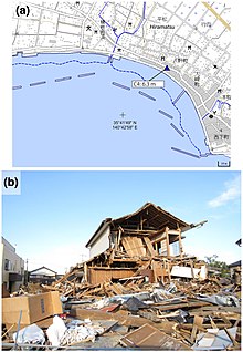
Am 11. März 2011 wurde die Stadt vom Tōhoku-Erdbeben und dem darauffolgenden Tsunami getroffen. Der Tsunami erreichte in Asahi lokal große Höhen.[3] Wohngebiete an der Pazifikküste nahmen in Asahi schwere Schäden[3] und 14 Menschen wurden getötet, 2 weitere blieben vermisst.[4][3] 318 Wohngebäude in Asahi wurden völlig und 847 weitere teilweise zerstört.[4] Im Ortsteil Hiramatsu (平松), der dicht mit Gebäude bebaut war, zeigten Wasserspuren eine Überflutungshöhe von 6,3 m an. Im Ortsteil Ashikawa (足川) wurde eine Überflutungshöhe von 5,1 m und eine Auflaufhöhe von 7,9 m gemessen.[3]
In der Stadt befindet sich das Museum „Ōhara Yūgaku kinenkan“ (大原幽学記念館), das dem Pädagogen Ōhara Yūgaku (1797–1858) gewidmet ist.
Verkehr
- Straße:
- Nationalstraße 126
- Zug:
Angrenzende Städte und Gemeinden
Städtepartnerschaften
- Chino, Japan
- Nakagusuku, Japan
Söhne und Töchter der Stadt
- Shōya Tomizawa (1990–2010), Motorradrennfahrer
Weblinks
Einzelnachweise
- ↑ 4月26日から新庁舎で業務を開始しました. In: Asahi-shi. 26. April 2021, abgerufen am 2. August 2021 (japanisch).
- ↑ Yoshinobu Tsuji, Kenji Satake, Takeo Ishibe, Tomoya Harada, Akihito Nishiyama, Satoshi Kusumoto: Tsunami Heights along the Pacific Coast of Northern Honshu Recorded from the 2011 Tohoku. In: Pure and Applied Geophysics. Band 171, Nr. 12, 2014, S. 3183–3215, doi:10.1007/s00024-014-0779-x. (Online veröffentlicht am 19. März 2014). Lizenz: Creative Commons Attribution 4.0 International (CC BY 4.0). Hier: S. 3194, Figure 13.
- ↑ a b c d Yoshinobu Tsuji, Kenji Satake, Takeo Ishibe, Tomoya Harada, Akihito Nishiyama, Satoshi Kusumoto: Tsunami Heights along the Pacific Coast of Northern Honshu Recorded from the 2011 Tohoku. In: Pure and Applied Geophysics. Band 171, Nr. 12, 2014, S. 3183–3215, doi:10.1007/s00024-014-0779-x. (Online veröffentlicht am 19. März 2014).
- ↑ a b 平成23年(2011年)東北地方太平洋沖地震(東日本大震災)について(第157報) (Memento vom 18. März 2018 auf WebCite) (PDF (Memento vom 18. März 2018 auf WebCite)), 総務省消防庁 (Fire and Disaster Management Agency), 157. Bericht, 7. März 2018.
Auf dieser Seite verwendete Medien
Autor/Urheber: Maximilian Dörrbecker (Chumwa), Lizenz: CC BY-SA 3.0
Postionskarte von Japan
Quadratische Plattkarte.
Bei Nutzung der Hauptkarte mit den Hauptinseln gelten folgende geographische Begrenzungen für die (Gesamt-)Karte:
- N: 45°51'37" N (45.86°N)
- S: 30°01'13" N (30.02°N)
- W: 128°14'24" O (128.24°O)
- O: 149°16'13" O (149.27°O)
Bei Nutzung der Nebenkarte mit den Ryūkyū-Inseln gelten folgende geographische Begrenzungen für die (Gesamt-)Karte:
- N: 39°32'25" N (39.54°N)
- S: 23°42'36" N (23.71°N)
- W: 110°25'49" O (110.43°O)
- O: 131°26'25" O (131.44°O)
Autor/Urheber: Yoshinobu Tsuji, Kenji Satake, Takeo Ishibe, Tomoya Harada, Akihito Nishiyama, Satoshi Kusumoto: "Tsunami Heights along the Pacific Coast of Northern Honshu Recorded from the 2011 Tohoku", Pure and Applied Geophysics, 171, 12, (2014), pp. 3183–3215, DOI:10.1007/s00024-014-0779-x, online published on 19 March 2014. License: Creative Commons Attribution 4.0 International (CC BY 4.0). Here p. 3194, Figure 13., Lizenz: CC BY 4.0
Source: Yoshinobu Tsuji, Kenji Satake, Takeo Ishibe, Tomoya Harada, Akihito Nishiyama, Satoshi Kusumoto: "Tsunami Heights along the Pacific Coast of Northern Honshu Recorded from the 2011 Tohoku", Pure and Applied Geophysics, 171, 12, (2014), pp. 3183–3215, DOI:10.1007/s00024-014-0779-x, online published on 19 March 2014. License: Creative Commons Attribution 4.0 International (CC BY 4.0). Here p. 3194, Figure 13.
Caption as given in the above cited source: "Figure 13 - a Tsunami height at Hiramatsu, Asahi City, Chiba Prefecture. The symbol and its meanings are the same as in Fig. 3. b A damaged house in Hiramatsu district"
Context as given in the above cited source: "At Asahi City, the tsunami heights were locally high. Residential areas along the Pacific coast were badly damaged and 13 people were killed (Fig. 13). In the Hiramatsu district where buildings were densely distributed, a clear watermark on the windows of a store indicated the inundation height as 6.3 m (C4). In the Ashikawa district, an inundation height of 5.1 m and a runup height of 7.9 m were measured (C5, C6)."Flag of Chiba Prefecture.
Autor/Urheber: Lincun / Update: ja:User:Knua, Lizenz: CC BY-SA 3.0
Location of Asahi in Chiba Prefecture
Flag of Asahi, Chiba


