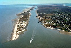
Intracoastal Waterway Louisiana
Autor/Urheber:
Lane Lefort, U.S. Army Corps of Engineers
Shortlink:
Quelle:
Größe:
1500 x 1000 Pixel (519983 Bytes)
Beschreibung:
Navigation on the Gulf Intracoastal Waterway (GIWW), where it intersects with Bayou Perot in Louisiana, USA. The view in this picture is to the south. The GIWW runs left–right across the picture. The bayou comes in from the left and enters Lake Salvador on the right. The bayou is the boundary between Jefferson Parish in the foreground and Lafourche Parish in the distance beyond the bayou.
Kommentar zur Lizenz:
This image or file is a work of a U.S. Army Corps of Engineers soldier or employee, taken or made as part of that person's official duties. As a work of the U.S. federal government, the image is in the public domain.
Lizenz:
Public domain
Credit:
U.S. Army Corps of Engineers Digital Visual Library
Image page
Image description page
Digital Visual Library home page
Image page
Image description page
Digital Visual Library home page
Relevante Bilder
Relevante Artikel
Gulf Intracoastal WaterwayDer Gulf Intracoastal Waterway (GIWW) ist eine Wasserstraße im Süden der Vereinigten Staaten und erstreckt sich entlang der Küste des Golf von Mexiko von Brownsville in Texas bis nach Fort Myers an der Westküste von Florida. Er bildet zusammen mit dem Atlantic Intracoastal Waterway, der von Florida bis nach Boston in Massachusetts reicht, den Intracoastal Waterway. .. weiterlesen

