Quartier des Quinze-Vingts
| Quartier des Quinze-Vingts | |
|---|---|
| Verwaltung | |
| Staat | Frankreich |
| Region | Île |
| Stadt | Paris |
| Arrondissement | 12. |
| Demographie | |
| Verkehrsanbindung | |
| Bahnhof | Gare de Lyon |
| Metro | |
Das Quartier des Quinze-Vingts ist das 48. der 80 Quartiers (Stadtviertel) von Paris. Das Viertel liegt im Nordosten der Stadt am Rive Droite genannten rechten Ufer der Seine und gehört zum 12. Arrondissement von Paris.
Lage

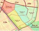
Das Quartier des Quinze-Vingts liegt am Seineufer, umgeben von den Quartiers de Picpus und de Bercy (im Osten), im Westen liegt das 4. und im Norden das 11. Arrondissement.
An der nördlichen Spitze des Viertels liegt der Place de la Bastille. Von hier bilden der Boulevard Bourdon im Osten und die Rue du Faubourg Saint-Antoine im Norden die Grenze. Südöstlich fließt die Seine und im Westen bilden die Rue Villiot (Sie führt unter den Gleisen des Gare de Lyon durch.) und die Rue de Rambouillet bis zum Place du Colonel Bourgoin, wo sie in die Rue de Chaligny abbiegt.
Geschichte
Plan von 1834 des Quartier des Quinze-Vingts im ehemaligen 8. Arrondissement
Während der französischen Revolution gab es schon eine Sektion des Quinze-Vingts.
Sehenswürdigkeiten

- Place de la Bastille mit Julisäule und der Opéra Bastille
- Gare de Lyon (Le Train Bleu)
- Port de l’Arsenal
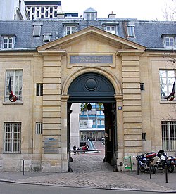
- Hôpital des Quinze-Vingts und Hôpital Saint-Antoine
- Viaduc des Arts und Coulée verte René-Dumont
Weblinks
Koordinaten: 48° 51′ N, 2° 23′ O
Auf dieser Seite verwendete Medien
The symbol of the Paris/Île-de-France RER
Transit icon for Line 1 of the Paris Métro. See {{Paris transit icons}} for colour standards.
Transit icon for Line 8 of the Paris Métro. See {{Paris transit icons}} for colour standards.
- own work
- line-art inspired by contemporary metro plans
Autor/Urheber: Mbzt, Lizenz: CC BY-SA 3.0
Quinze-Vingt hospital - Paris
Engraved hand colored plan of 1 st. Borough, Faubroug du Roule, administrative district of Paris, with view of the Church of Saint -Philioppe du Roule. Shows roads, streets, monuments, city blocks, public buildings, etc. Includes explanation to symbols on the map and statistical table. This is the first edition of an extremely uncommon atlas of the forty-eight districts of the city of Paris. Includes 50 color maps, a manuscript index and 48 pages of index to the neighborhoods and districts. Bound in green paper covers, with title "Petit atlas pittoresque des 48 quartiers de la ville de Paris, avec un tableau d'assemblage. Par A.-M. Perrot, Ingenieur." pasted on the cover.
Transit icon for Line 5 of the Paris Métro. See {{Paris transit icons}} for colour standards.
- own work
- line-art inspired by contemporary metro plans
Logo der Metro Paris
Autor/Urheber: Starus, Lizenz: CC BY-SA 3.0
12th arrondissement of Paris with sectors


