Machias Seal Island
| Machias Seal Island | ||
|---|---|---|
| Machias Seal Island | ||
| Gewässer | Golf von Maine (Atlantischer Ozean) | |
| Geographische Lage | 44° 30′ 10″ N, 67° 6′ 10″ W | |
| Fläche | 8 ha | |
| Einwohner | unbewohnt | |
Machias Seal Island ist eine unbewohnte Atlantik-Insel vor Maine, USA, mit einer Fläche von ca. 80.000 m².
Seit 1832 besteht ein Gebietsdisput mit Kanada im Rahmen der Gebietsansprüche zwischen Kanada und den Vereinigten Staaten. Die Insel war in den 1970er und 1980er Jahren von den Familien der Leuchtfeuerwärter der Canadian Coast Guard bewohnt.
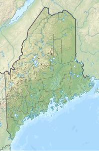
Die Insel befindet sich im Golf von Maine, etwa 16 km südöstlich von Cutler (Maine) und ca. 19 km südwestlich von Southwest Head (New Brunswick; nahe Grand Manan Island).
Trivia
- Aufgrund der doppelten Gebietsansprüche sind alle Personen, welche auf dieser Insel zur Welt kommen, sowohl US- als auch kanadische Staatsbürger.
Auf dieser Seite verwendete Medien
Autor/Urheber: SANtosito, Lizenz: CC BY-SA 4.0
Relief location map of Maine, USA
Geographic limits of the map:
- N: 47.7° N
- S: 42.7° N
- W: 71.3° W
- E: 66.7° W


